You are here: Home > Network List > TA - USArray Transportable Network (new EarthScope stations) Stations List
> Station M47A Cromwell, IN, USA > Earthquake Result Viewer
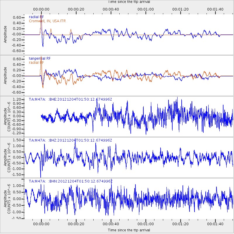
M47A Cromwell, IN, USA - Earthquake Result Viewer
*The percent match for this event was below the threshold and hence no stack was calculated.
| Earthquake location: |
Southern Alaska |
| Earthquake latitude/longitude: |
61.2/-150.8 |
| Earthquake time(UTC): |
2012/12/04 (339) 01:42:48 GMT |
| Earthquake Depth: |
62 km |
| Earthquake Magnitude: |
5.6 MB, 5.8 MW, 5.7 MW |
| Earthquake Catalog/Contributor: |
WHDF/NEIC |
|
| Network: |
TA USArray Transportable Network (new EarthScope stations) |
| Station: |
M47A Cromwell, IN, USA |
| Lat/Lon: |
41.36 N/85.62 W |
| Elevation: |
283 m |
|
| Distance: |
43.2 deg |
| Az: |
86.532 deg |
| Baz: |
320.108 deg |
| Ray Param: |
$rayparam |
*The percent match for this event was below the threshold and hence was not used in the summary stack. |
|
| Radial Match: |
56.975 % |
| Radial Bump: |
400 |
| Transverse Match: |
55.484962 % |
| Transverse Bump: |
400 |
| SOD ConfigId: |
488671 |
| Insert Time: |
2013-03-29 03:49:23.906 +0000 |
| GWidth: |
2.5 |
| Max Bumps: |
400 |
| Tol: |
0.001 |
|
Signal To Noise
| Channel | StoN | STA | LTA |
| TA:M47A: :BHZ:20121204T01:50:12.674996Z | 2.477637 | 5.6575544E-7 | 2.2834476E-7 |
| TA:M47A: :BHN:20121204T01:50:12.674996Z | 1.2643683 | 4.6849627E-7 | 3.705378E-7 |
| TA:M47A: :BHE:20121204T01:50:12.674996Z | 2.63372 | 5.1885297E-7 | 1.9700386E-7 |
| Arrivals |
| Ps | |
| PpPs | |
| PsPs/PpSs | |


