You are here: Home > Network List > TA - USArray Transportable Network (new EarthScope stations) Stations List
> Station J46A Howard City, MI, USA > Earthquake Result Viewer
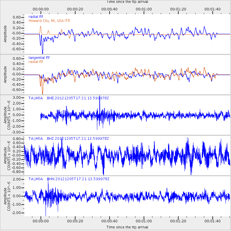
J46A Howard City, MI, USA - Earthquake Result Viewer
*The percent match for this event was below the threshold and hence no stack was calculated.
| Earthquake location: |
Northern And Central Iran |
| Earthquake latitude/longitude: |
33.5/59.6 |
| Earthquake time(UTC): |
2012/12/05 (340) 17:08:13 GMT |
| Earthquake Depth: |
14 km |
| Earthquake Magnitude: |
5.6 MB, 5.6 MS, 5.8 MW, 5.6 MW |
| Earthquake Catalog/Contributor: |
WHDF/NEIC |
|
| Network: |
TA USArray Transportable Network (new EarthScope stations) |
| Station: |
J46A Howard City, MI, USA |
| Lat/Lon: |
43.35 N/85.65 W |
| Elevation: |
275 m |
|
| Distance: |
97.2 deg |
| Az: |
335.201 deg |
| Baz: |
28.711 deg |
| Ray Param: |
$rayparam |
*The percent match for this event was below the threshold and hence was not used in the summary stack. |
|
| Radial Match: |
56.446484 % |
| Radial Bump: |
400 |
| Transverse Match: |
40.991783 % |
| Transverse Bump: |
400 |
| SOD ConfigId: |
488671 |
| Insert Time: |
2013-03-29 03:59:20.727 +0000 |
| GWidth: |
2.5 |
| Max Bumps: |
400 |
| Tol: |
0.001 |
|
Signal To Noise
| Channel | StoN | STA | LTA |
| TA:J46A: :BHZ:20121205T17:21:13.599978Z | 0.9039331 | 2.4380023E-7 | 2.6971048E-7 |
| TA:J46A: :BHN:20121205T17:21:13.599978Z | 1.8984619 | 5.631915E-7 | 2.9665674E-7 |
| TA:J46A: :BHE:20121205T17:21:13.599978Z | 1.4539967 | 6.447016E-7 | 4.4339964E-7 |
| Arrivals |
| Ps | |
| PpPs | |
| PsPs/PpSs | |


