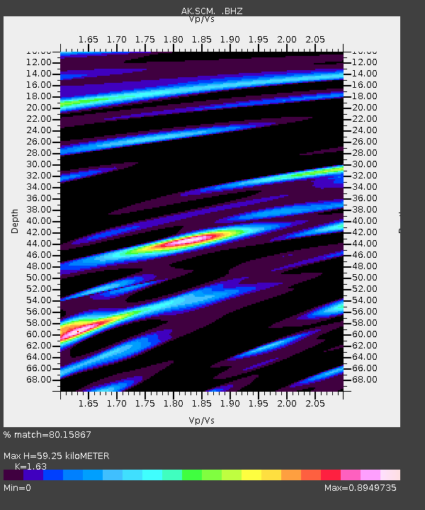
SCM Sheep Mountain - Earthquake Result Viewer

Earthquake location: Off East Coast Of Honshu, Japan
Earthquake latitude/longitude: 37.9/143.9
Earthquake time(UTC): 2012/12/07 (342) 08:18:23 GMT
Earthquake Depth: 31 km
Earthquake Magnitude: 7.2 MB, 7.3 MS, 7.3 MW, 7.3 MW
Earthquake Catalog/Contributor: WHDF/NEIC
Network: AK Alaska Regional Network
Station: SCM Sheep Mountain
Lat/Lon: 61.83 N/147.33 W
Elevation: 1056 m
Distance: 47.6 deg
Az: 36.797 deg
Baz: 272.912 deg
Ray Param: 0.06984114
Estimated Moho Depth: 59.25 km
Estimated Crust Vp/Vs: 1.63
Assumed Crust Vp: 6.566 km/s
Estimated Crust Vs: 4.028 km/s
Estimated Crust Poisson's Ratio: 0.20
Radial Match: 80.15867 %
Radial Bump: 400
Transverse Match: 80.26605 %
Transverse Bump: 400
SOD ConfigId: 488671
Insert Time: 2013-03-29 04:03:46.499 +0000
GWidth: 2.5
Max Bumps: 400
Tol: 0.001

Signal To Noise

ChannelStoNSTALTA
AK:SCM: :BHZ:20121207T08:26:25.268Z148.38933.555269E-52.3959066E-7
AK:SCM: :BHN:20121207T08:26:25.268Z17.5262765.5633705E-63.1743028E-7
AK:SCM: :BHE:20121207T08:26:25.268Z48.7199171.9976595E-54.100293E-7
Arrivals
Ps6.1 SECOND
PpPs22 SECOND
PsPs/PpSs28 SECOND