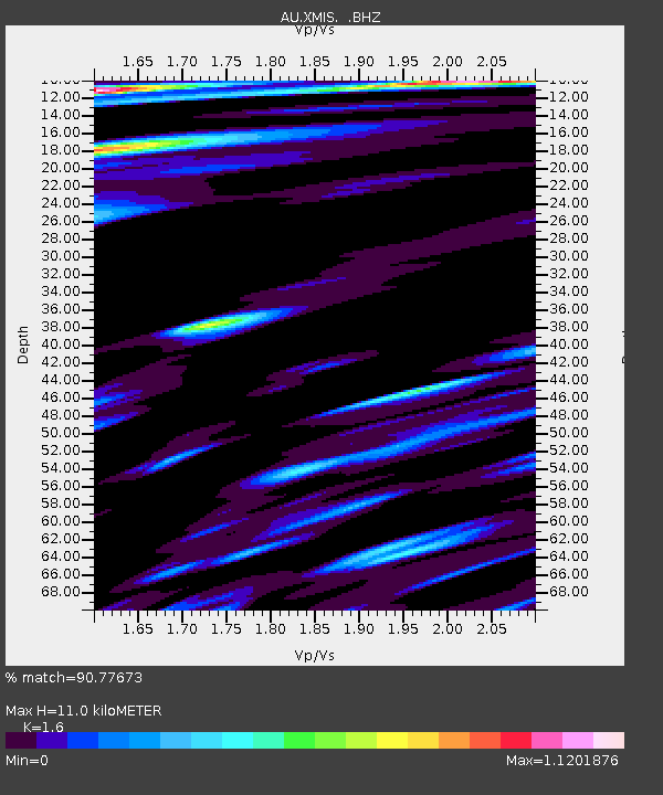
XMIS Christmas Island Grants Well - Earthquake Result Viewer

Earthquake location: Off East Coast Of Honshu, Japan
Earthquake latitude/longitude: 37.9/143.9
Earthquake time(UTC): 2012/12/07 (342) 08:18:23 GMT
Earthquake Depth: 31 km
Earthquake Magnitude: 7.2 MB, 7.3 MS, 7.3 MW, 7.3 MW
Earthquake Catalog/Contributor: WHDF/NEIC
Network: AU Australian Seismological Centre
Station: XMIS Christmas Island Grants Well
Lat/Lon: 10.48 S/105.65 E
Elevation: 210 m
Distance: 60.0 deg
Az: 224.742 deg
Baz: 34.489 deg
Ray Param: 0.061776593
Estimated Moho Depth: 11.0 km
Estimated Crust Vp/Vs: 1.60
Assumed Crust Vp: 4.157 km/s
Estimated Crust Vs: 2.598 km/s
Estimated Crust Poisson's Ratio: 0.18
Radial Match: 90.77673 %
Radial Bump: 400
Transverse Match: 89.04326 %
Transverse Bump: 400
SOD ConfigId: 488671
Insert Time: 2013-03-29 04:06:06.939 +0000
GWidth: 2.5
Max Bumps: 400
Tol: 0.001

Signal To Noise

ChannelStoNSTALTA
AU:XMIS: :BHZ:20121207T08:27:55.820002Z24.5808287.0172537E-62.854767E-7
AU:XMIS: :BHN:20121207T08:27:55.820002Z12.7769152.9889857E-62.3393642E-7
AU:XMIS: :BHE:20121207T08:27:55.820002Z8.8049372.261201E-62.5681058E-7
Arrivals
Ps1.6 SECOND
PpPs6.7 SECOND
PsPs/PpSs8.4 SECOND