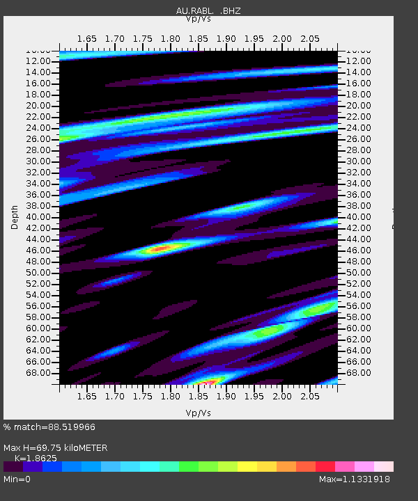
RABL Rabaul, Papau New Guinea - Earthquake Result Viewer

Earthquake location: Off East Coast Of Honshu, Japan
Earthquake latitude/longitude: 37.9/143.9
Earthquake time(UTC): 2012/12/07 (342) 08:18:23 GMT
Earthquake Depth: 31 km
Earthquake Magnitude: 7.2 MB, 7.3 MS, 7.3 MW, 7.3 MW
Earthquake Catalog/Contributor: WHDF/NEIC
Network: AU Australian Seismological Centre
Station: RABL Rabaul, Papau New Guinea
Lat/Lon: 4.19 S/152.16 E
Elevation: 277 m
Distance: 42.6 deg
Az: 167.836 deg
Baz: 350.378 deg
Ray Param: 0.0730496
Estimated Moho Depth: 69.75 km
Estimated Crust Vp/Vs: 1.86
Assumed Crust Vp: 6.183 km/s
Estimated Crust Vs: 3.32 km/s
Estimated Crust Poisson's Ratio: 0.30
Radial Match: 88.519966 %
Radial Bump: 400
Transverse Match: 79.552956 %
Transverse Bump: 400
SOD ConfigId: 488671
Insert Time: 2013-03-29 04:06:36.051 +0000
GWidth: 2.5
Max Bumps: 400
Tol: 0.001

Signal To Noise

ChannelStoNSTALTA
AU:RABL: :BHZ:20121207T08:25:45.445002Z86.264162.0770525E-52.4077815E-7
AU:RABL: :BHN:20121207T08:25:45.445002Z23.1925181.0724886E-54.6242872E-7
AU:RABL: :BHE:20121207T08:25:45.445002Z6.44489242.857501E-64.433745E-7
Arrivals
Ps10 SECOND
PpPs30 SECOND
PsPs/PpSs41 SECOND