You are here: Home > Network List > UW - Pacific Northwest Regional Seismic Network Stations List
> Station LEBA Lebam, WA, USA > Earthquake Result Viewer
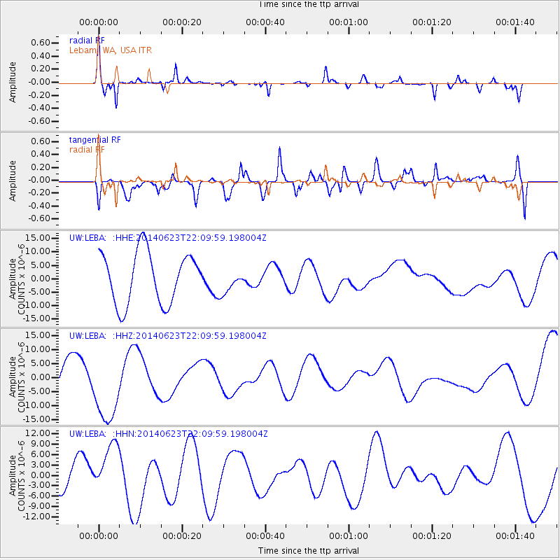
LEBA Lebam, WA, USA - Earthquake Result Viewer
*The percent match for this event was below the threshold and hence no stack was calculated.
| Earthquake location: |
Rat Islands, Aleutian Islands |
| Earthquake latitude/longitude: |
52.0/178.4 |
| Earthquake time(UTC): |
2014/06/23 (174) 22:03:28 GMT |
| Earthquake Depth: |
120 km |
| Earthquake Magnitude: |
5.1 mb |
| Earthquake Catalog/Contributor: |
ISC/ISC |
|
| Network: |
UW Pacific Northwest Regional Seismic Network |
| Station: |
LEBA Lebam, WA, USA |
| Lat/Lon: |
46.55 N/123.56 W |
| Elevation: |
73 m |
|
| Distance: |
37.4 deg |
| Az: |
74.67 deg |
| Baz: |
300.181 deg |
| Ray Param: |
$rayparam |
*The percent match for this event was below the threshold and hence was not used in the summary stack. |
|
| Radial Match: |
56.57542 % |
| Radial Bump: |
339 |
| Transverse Match: |
41.309162 % |
| Transverse Bump: |
400 |
| SOD ConfigId: |
3390531 |
| Insert Time: |
2019-04-12 11:16:16.575 +0000 |
| GWidth: |
2.5 |
| Max Bumps: |
400 |
| Tol: |
0.001 |
|
Signal To Noise
| Channel | StoN | STA | LTA |
| UW:LEBA: :HHZ:20140623T22:09:59.198004Z | 1.9536881 | 1.4179556E-5 | 7.25784E-6 |
| UW:LEBA: :HHN:20140623T22:09:59.198004Z | 1.454392 | 7.9583E-6 | 5.4719085E-6 |
| UW:LEBA: :HHE:20140623T22:09:59.198004Z | 0.46886402 | 4.4811677E-6 | 9.5575E-6 |
| Arrivals |
| Ps | |
| PpPs | |
| PsPs/PpSs | |


