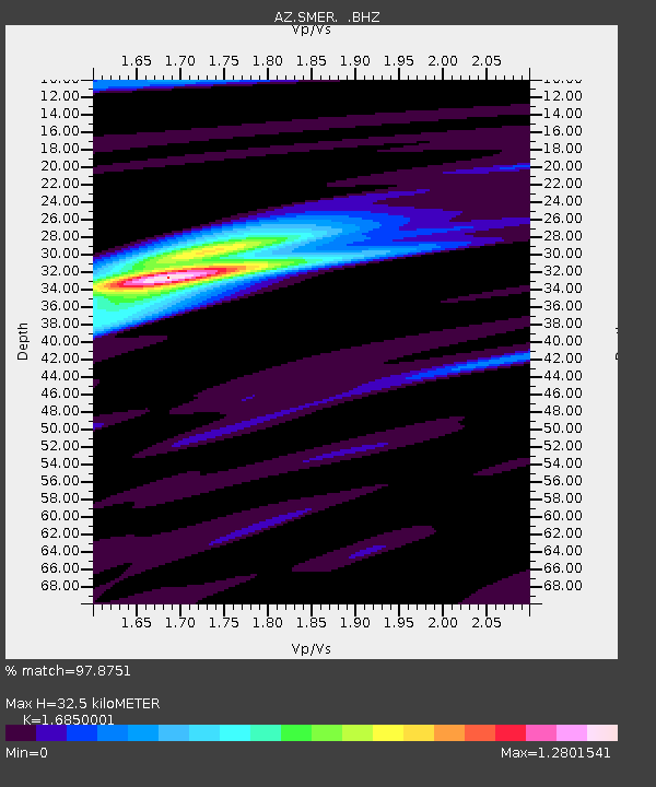
SMER AZ.SMER - Earthquake Result Viewer
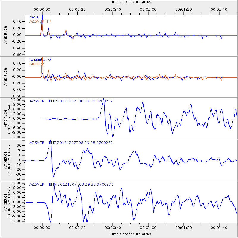
Earthquake location: Off East Coast Of Honshu, Japan
Earthquake latitude/longitude: 37.9/143.9
Earthquake time(UTC): 2012/12/07 (342) 08:18:23 GMT
Earthquake Depth: 31 km
Earthquake Magnitude: 7.2 MB, 7.3 MS, 7.3 MW, 7.3 MW
Earthquake Catalog/Contributor: WHDF/NEIC
Network: AZ ANZA Regional Network
Station: SMER AZ.SMER
Lat/Lon: 33.46 N/117.17 W
Elevation: 355 m
Distance: 76.5 deg
Az: 58.152 deg
Baz: 306.494 deg
Ray Param: 0.050912358
Estimated Moho Depth: 32.5 km
Estimated Crust Vp/Vs: 1.69
Assumed Crust Vp: 6.264 km/s
Estimated Crust Vs: 3.717 km/s
Estimated Crust Poisson's Ratio: 0.23
Radial Match: 97.8751 %
Radial Bump: 285
Transverse Match: 90.931145 %
Transverse Bump: 400
SOD ConfigId: 488671
Insert Time: 2013-03-29 04:07:58.036 +0000
GWidth: 2.5
Max Bumps: 400
Tol: 0.001

Signal To Noise

ChannelStoNSTALTA
AZ:SMER: :BHZ:20121207T08:29:38.970027Z126.857331.7965094E-51.4161652E-7
AZ:SMER: :BHN:20121207T08:29:38.970027Z31.633235.0236135E-61.588081E-7
AZ:SMER: :BHE:20121207T08:29:38.970027Z31.0550275.1697125E-61.6646943E-7
Arrivals
Ps3.7 SECOND
PpPs14 SECOND
PsPs/PpSs17 SECOND