You are here: Home > Network List > CI - Caltech Regional Seismic Network Stations List
> Station LGU LGU, Camarillo, CA, USA > Earthquake Result Viewer
LGU LGU, Camarillo, CA, USA - Earthquake Result Viewer
| Earthquake location: |
Off East Coast Of Honshu, Japan |
| Earthquake latitude/longitude: |
37.9/143.9 |
| Earthquake time(UTC): |
2012/12/07 (342) 08:18:23 GMT |
| Earthquake Depth: |
31 km |
| Earthquake Magnitude: |
7.2 MB, 7.3 MS, 7.3 MW, 7.3 MW |
| Earthquake Catalog/Contributor: |
WHDF/NEIC |
|
| Network: |
CI Caltech Regional Seismic Network |
| Station: |
LGU LGU, Camarillo, CA, USA |
| Lat/Lon: |
34.11 N/119.07 W |
| Elevation: |
416 m |
|
| Distance: |
74.8 deg |
| Az: |
58.568 deg |
| Baz: |
305.548 deg |
| Ray Param: |
0.052020635 |
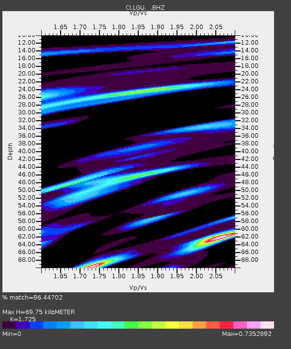
| Estimated Moho Depth: |
69.75 km |
| Estimated Crust Vp/Vs: |
1.73 |
| Assumed Crust Vp: |
6.1 km/s |
| Estimated Crust Vs: |
3.536 km/s |
| Estimated Crust Poisson's Ratio: |
0.25 |
|
| Radial Match: |
96.44702 % |
| Radial Bump: |
400 |
| Transverse Match: |
91.91173 % |
| Transverse Bump: |
400 |
| SOD ConfigId: |
488671 |
| Insert Time: |
2013-03-29 04:12:06.498 +0000 |
| GWidth: |
2.5 |
| Max Bumps: |
400 |
| Tol: |
0.001 |
|

Signal To Noise
| Channel | StoN | STA | LTA |
| CI:LGU: :BHZ:20121207T08:29:29.49499Z | 65.069916 | 2.0530731E-5 | 3.1551804E-7 |
| CI:LGU: :BHN:20121207T08:29:29.49499Z | 20.029928 | 6.2547088E-6 | 3.1226816E-7 |
| CI:LGU: :BHE:20121207T08:29:29.49499Z | 12.446592 | 5.437839E-6 | 4.3689377E-7 |
| Arrivals |
| Ps | 8.5 SECOND |
| PpPs | 30 SECOND |
| PsPs/PpSs | 39 SECOND |


