You are here: Home > Network List > CI - Caltech Regional Seismic Network Stations List
> Station FMP Fort MacArthur Park, Pt. Fermin San Pedro, CA, USA > Earthquake Result Viewer
FMP Fort MacArthur Park, Pt. Fermin San Pedro, CA, USA - Earthquake Result Viewer
| Earthquake location: |
Off East Coast Of Honshu, Japan |
| Earthquake latitude/longitude: |
37.9/143.9 |
| Earthquake time(UTC): |
2012/12/07 (342) 08:18:23 GMT |
| Earthquake Depth: |
31 km |
| Earthquake Magnitude: |
7.2 MB, 7.3 MS, 7.3 MW, 7.3 MW |
| Earthquake Catalog/Contributor: |
WHDF/NEIC |
|
| Network: |
CI Caltech Regional Seismic Network |
| Station: |
FMP Fort MacArthur Park, Pt. Fermin San Pedro, CA, USA |
| Lat/Lon: |
33.71 N/118.29 W |
| Elevation: |
89 m |
|
| Distance: |
75.6 deg |
| Az: |
58.511 deg |
| Baz: |
305.962 deg |
| Ray Param: |
0.05152298 |
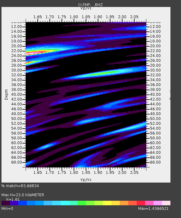
| Estimated Moho Depth: |
23.0 km |
| Estimated Crust Vp/Vs: |
1.61 |
| Assumed Crust Vp: |
6.048 km/s |
| Estimated Crust Vs: |
3.756 km/s |
| Estimated Crust Poisson's Ratio: |
0.19 |
|
| Radial Match: |
93.66934 % |
| Radial Bump: |
400 |
| Transverse Match: |
87.66908 % |
| Transverse Bump: |
400 |
| SOD ConfigId: |
488671 |
| Insert Time: |
2013-03-29 04:12:46.622 +0000 |
| GWidth: |
2.5 |
| Max Bumps: |
400 |
| Tol: |
0.001 |
|
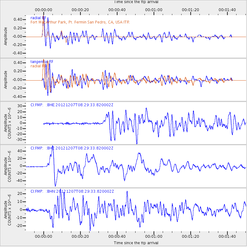
Signal To Noise
| Channel | StoN | STA | LTA |
| CI:FMP: :BHZ:20121207T08:29:33.820002Z | 51.740833 | 2.0029174E-5 | 3.8710576E-7 |
| CI:FMP: :BHN:20121207T08:29:33.820002Z | 6.7381234 | 5.2598316E-6 | 7.806078E-7 |
| CI:FMP: :BHE:20121207T08:29:33.820002Z | 9.566739 | 6.315301E-6 | 6.6013104E-7 |
| Arrivals |
| Ps | 2.4 SECOND |
| PpPs | 9.6 SECOND |
| PsPs/PpSs | 12 SECOND |


