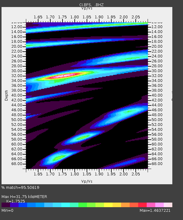
BFS Mt Baldy Forest Station - Earthquake Result Viewer
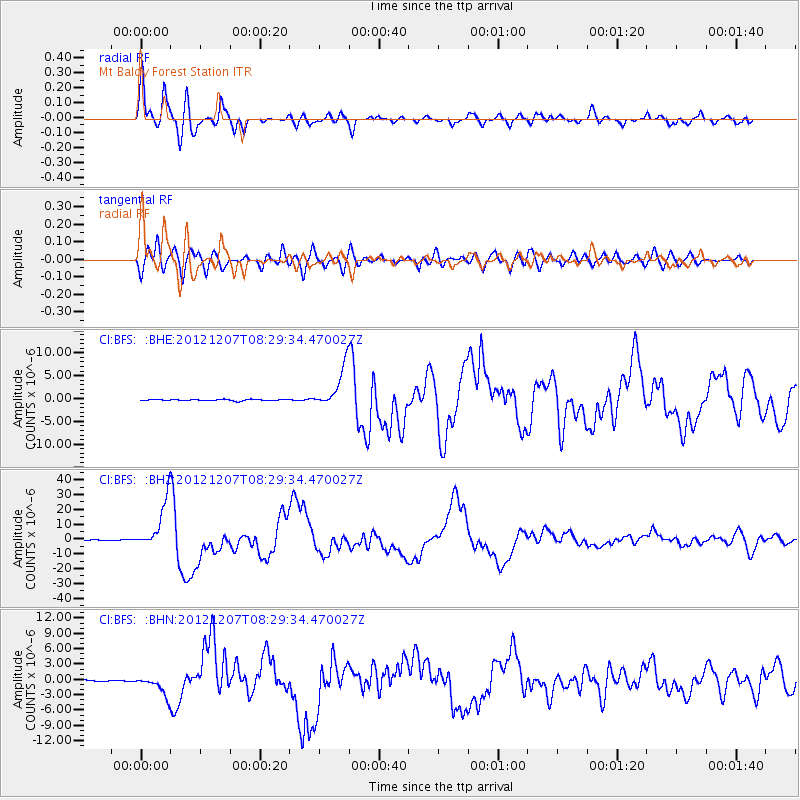
Earthquake location: Off East Coast Of Honshu, Japan
Earthquake latitude/longitude: 37.9/143.9
Earthquake time(UTC): 2012/12/07 (342) 08:18:23 GMT
Earthquake Depth: 31 km
Earthquake Magnitude: 7.2 MB, 7.3 MS, 7.3 MW, 7.3 MW
Earthquake Catalog/Contributor: WHDF/NEIC
Network: CI Caltech Regional Seismic Network
Station: BFS Mt Baldy Forest Station
Lat/Lon: 34.24 N/117.66 W
Elevation: 1312 m
Distance: 75.7 deg
Az: 57.753 deg
Baz: 306.127 deg
Ray Param: 0.051443275
Estimated Moho Depth: 31.75 km
Estimated Crust Vp/Vs: 1.75
Assumed Crust Vp: 6.276 km/s
Estimated Crust Vs: 3.581 km/s
Estimated Crust Poisson's Ratio: 0.26
Radial Match: 95.50619 %
Radial Bump: 400
Transverse Match: 87.993706 %
Transverse Bump: 400
SOD ConfigId: 488671
Insert Time: 2013-03-29 04:13:15.633 +0000
GWidth: 2.5
Max Bumps: 400
Tol: 0.001

Signal To Noise

ChannelStoNSTALTA
CI:BFS: :BHZ:20121207T08:29:34.470027Z79.77211.6162392E-52.0260707E-7
CI:BFS: :BHN:20121207T08:29:34.470027Z16.5409551.873691E-61.13275874E-7
CI:BFS: :BHE:20121207T08:29:34.470027Z30.9241584.5519964E-61.4719872E-7
Arrivals
Ps3.9 SECOND
PpPs14 SECOND
PsPs/PpSs17 SECOND