You are here: Home > Network List > CI - Caltech Regional Seismic Network Stations List
> Station TUQ Turquiose Mountain, Baker, CA, USA > Earthquake Result Viewer
TUQ Turquiose Mountain, Baker, CA, USA - Earthquake Result Viewer
| Earthquake location: |
Off East Coast Of Honshu, Japan |
| Earthquake latitude/longitude: |
37.9/143.9 |
| Earthquake time(UTC): |
2012/12/07 (342) 08:18:23 GMT |
| Earthquake Depth: |
31 km |
| Earthquake Magnitude: |
7.2 MB, 7.3 MS, 7.3 MW, 7.3 MW |
| Earthquake Catalog/Contributor: |
WHDF/NEIC |
|
| Network: |
CI Caltech Regional Seismic Network |
| Station: |
TUQ Turquiose Mountain, Baker, CA, USA |
| Lat/Lon: |
35.44 N/115.92 W |
| Elevation: |
1350 m |
|
| Distance: |
76.1 deg |
| Az: |
55.889 deg |
| Baz: |
306.661 deg |
| Ray Param: |
0.051146146 |
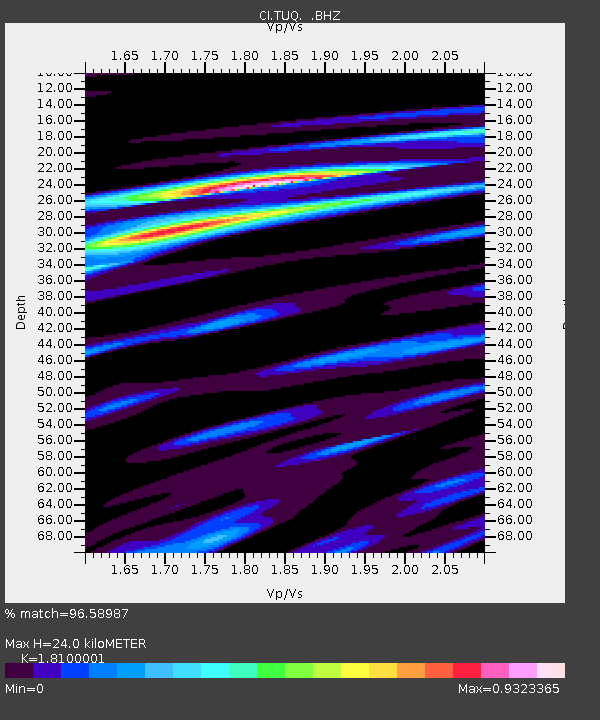
| Estimated Moho Depth: |
24.0 km |
| Estimated Crust Vp/Vs: |
1.81 |
| Assumed Crust Vp: |
6.276 km/s |
| Estimated Crust Vs: |
3.467 km/s |
| Estimated Crust Poisson's Ratio: |
0.28 |
|
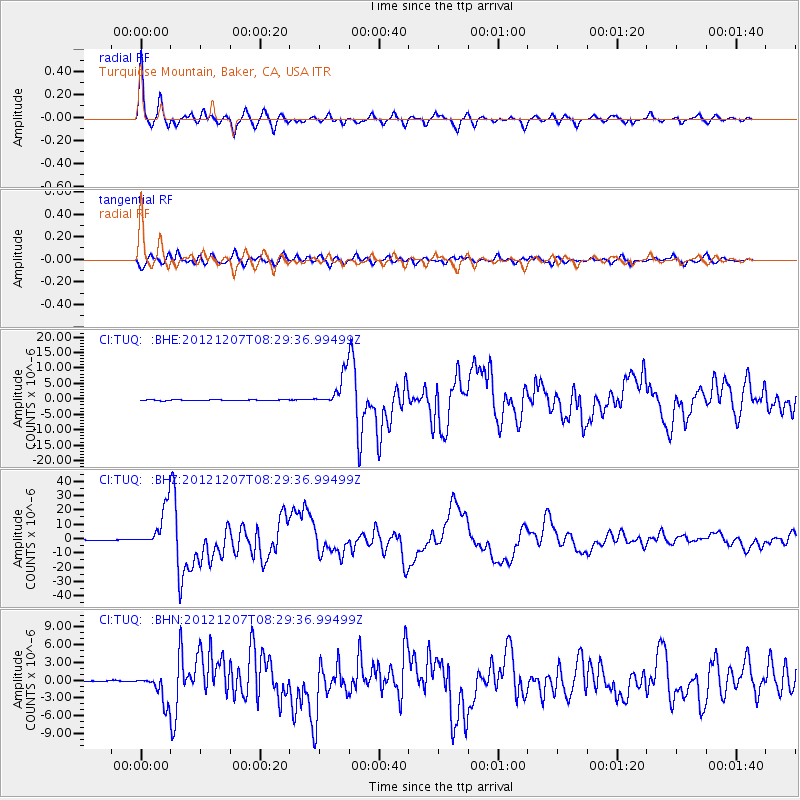
| Radial Match: |
96.58987 % |
| Radial Bump: |
348 |
| Transverse Match: |
89.596924 % |
| Transverse Bump: |
400 |
| SOD ConfigId: |
488671 |
| Insert Time: |
2013-03-29 04:13:32.915 +0000 |
| GWidth: |
2.5 |
| Max Bumps: |
400 |
| Tol: |
0.001 |
|
Signal To Noise
| Channel | StoN | STA | LTA |
| CI:TUQ: :BHZ:20121207T08:29:36.99499Z | 88.52347 | 1.4292684E-5 | 1.6145644E-7 |
| CI:TUQ: :BHN:20121207T08:29:36.99499Z | 16.861893 | 2.3572943E-6 | 1.3980011E-7 |
| CI:TUQ: :BHE:20121207T08:29:36.99499Z | 42.634205 | 5.2162018E-6 | 1.2234781E-7 |
| Arrivals |
| Ps | 3.2 SECOND |
| PpPs | 10 SECOND |
| PsPs/PpSs | 14 SECOND |


