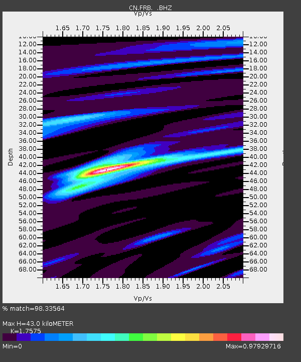
FRB IQALUIT, N.W.T. - Earthquake Result Viewer

Earthquake location: Off East Coast Of Honshu, Japan
Earthquake latitude/longitude: 37.9/143.9
Earthquake time(UTC): 2012/12/07 (342) 08:18:23 GMT
Earthquake Depth: 31 km
Earthquake Magnitude: 7.2 MB, 7.3 MS, 7.3 MW, 7.3 MW
Earthquake Catalog/Contributor: WHDF/NEIC
Network: CN Canadian National Seismograph Network
Station: FRB IQALUIT, N.W.T.
Lat/Lon: 63.75 N/68.55 W
Elevation: 18 m
Distance: 75.5 deg
Az: 14.29 deg
Baz: 333.953 deg
Ray Param: 0.051608548
Estimated Moho Depth: 43.0 km
Estimated Crust Vp/Vs: 1.76
Assumed Crust Vp: 6.419 km/s
Estimated Crust Vs: 3.652 km/s
Estimated Crust Poisson's Ratio: 0.26
Radial Match: 98.33564 %
Radial Bump: 302
Transverse Match: 91.068794 %
Transverse Bump: 400
SOD ConfigId: 488671
Insert Time: 2013-03-29 04:14:11.411 +0000
GWidth: 2.5
Max Bumps: 400
Tol: 0.001

Signal To Noise

ChannelStoNSTALTA
CN:FRB: :BHZ:20121207T08:29:33.075007Z73.5908362.4213457E-53.2902815E-7
CN:FRB: :BHN:20121207T08:29:33.075007Z44.181959.309974E-62.1071897E-7
CN:FRB: :BHE:20121207T08:29:33.075007Z26.9693664.561369E-61.691315E-7
Arrivals
Ps5.2 SECOND
PpPs18 SECOND
PsPs/PpSs23 SECOND