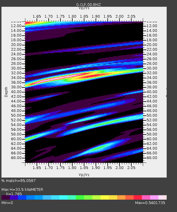
CLF Chambon la Foret observatory, France - Earthquake Result Viewer
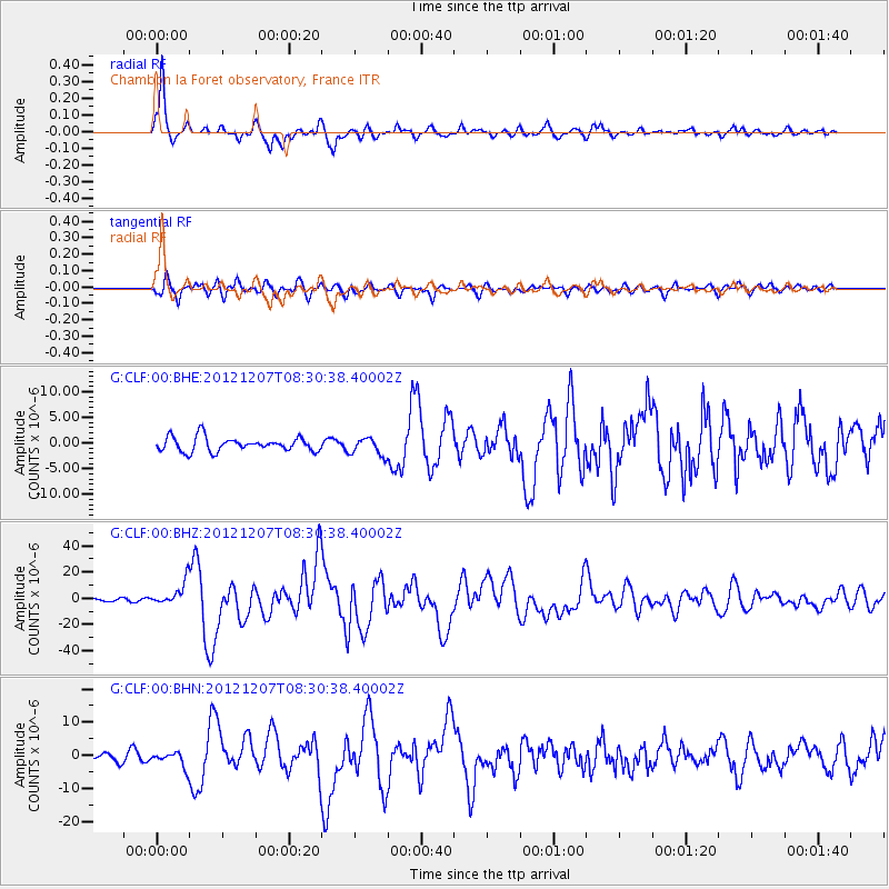
Earthquake location: Off East Coast Of Honshu, Japan
Earthquake latitude/longitude: 37.9/143.9
Earthquake time(UTC): 2012/12/07 (342) 08:18:23 GMT
Earthquake Depth: 31 km
Earthquake Magnitude: 7.2 MB, 7.3 MS, 7.3 MW, 7.3 MW
Earthquake Catalog/Contributor: WHDF/NEIC
Network: G GEOSCOPE
Station: CLF Chambon la Foret observatory, France
Lat/Lon: 48.03 N/2.26 E
Elevation: 145 m
Distance: 87.9 deg
Az: 335.391 deg
Baz: 29.394 deg
Ray Param: 0.04294461
Estimated Moho Depth: 33.5 km
Estimated Crust Vp/Vs: 1.76
Assumed Crust Vp: 6.12 km/s
Estimated Crust Vs: 3.467 km/s
Estimated Crust Poisson's Ratio: 0.26
Radial Match: 95.0597 %
Radial Bump: 393
Transverse Match: 87.71821 %
Transverse Bump: 400
SOD ConfigId: 488671
Insert Time: 2013-03-29 04:15:40.939 +0000
GWidth: 2.5
Max Bumps: 400
Tol: 0.001

Signal To Noise

ChannelStoNSTALTA
G:CLF:00:BHZ:20121207T08:30:38.40002Z10.7706738.885207E-68.2494444E-7
G:CLF:00:BHN:20121207T08:30:38.40002Z1.8011082.2479612E-61.2480991E-6
G:CLF:00:BHE:20121207T08:30:38.40002Z1.25055221.6989703E-61.3585761E-6
Arrivals
Ps4.3 SECOND
PpPs15 SECOND
PsPs/PpSs19 SECOND