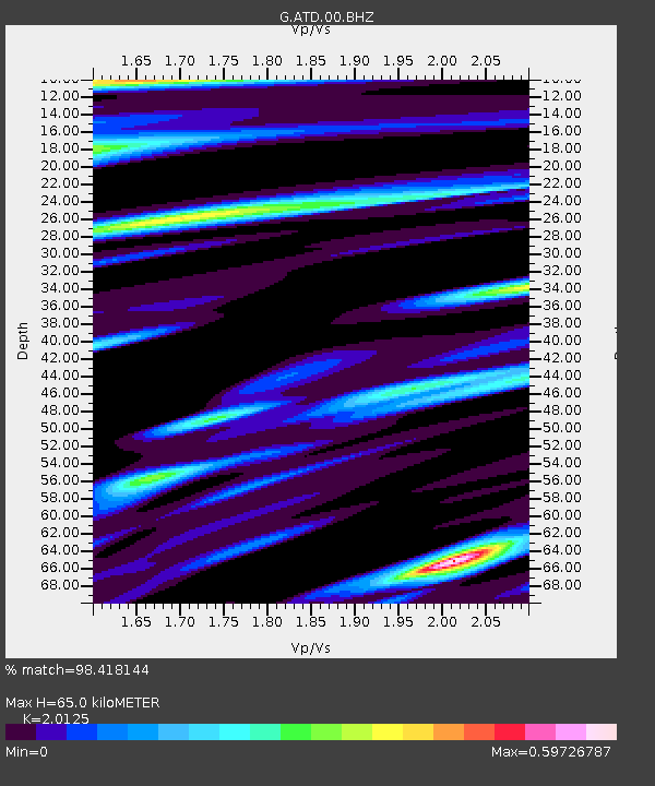
ATD Arta Cave - Arta, Republic of Djibouti - Earthquake Result Viewer
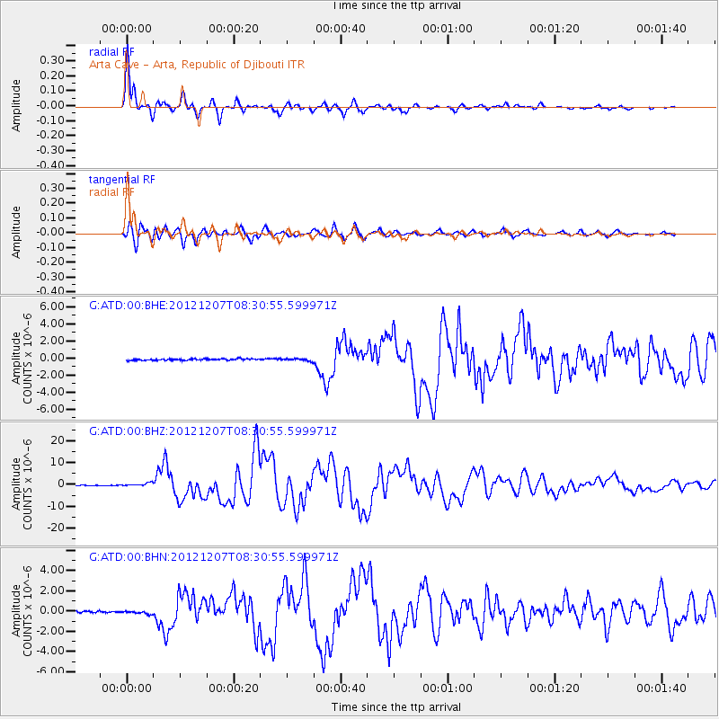
Earthquake location: Off East Coast Of Honshu, Japan
Earthquake latitude/longitude: 37.9/143.9
Earthquake time(UTC): 2012/12/07 (342) 08:18:23 GMT
Earthquake Depth: 31 km
Earthquake Magnitude: 7.2 MB, 7.3 MS, 7.3 MW, 7.3 MW
Earthquake Catalog/Contributor: WHDF/NEIC
Network: G GEOSCOPE
Station: ATD Arta Cave - Arta, Republic of Djibouti
Lat/Lon: 11.53 N/42.85 E
Elevation: 610 m
Distance: 91.6 deg
Az: 285.823 deg
Baz: 50.957 deg
Ray Param: 0.04157814
Estimated Moho Depth: 65.0 km
Estimated Crust Vp/Vs: 2.01
Assumed Crust Vp: 6.375 km/s
Estimated Crust Vs: 3.168 km/s
Estimated Crust Poisson's Ratio: 0.34
Radial Match: 98.418144 %
Radial Bump: 388
Transverse Match: 94.35973 %
Transverse Bump: 400
SOD ConfigId: 488671
Insert Time: 2013-03-29 04:15:42.097 +0000
GWidth: 2.5
Max Bumps: 400
Tol: 0.001

Signal To Noise

ChannelStoNSTALTA
G:ATD:00:BHZ:20121207T08:30:55.599971Z8.5094717.6898164E-79.0367735E-8
G:ATD:00:BHN:20121207T08:30:55.599971Z1.8033131.5946132E-78.8426866E-8
G:ATD:00:BHE:20121207T08:30:55.599971Z1.62485771.4186368E-78.7308365E-8
Arrivals
Ps11 SECOND
PpPs30 SECOND
PsPs/PpSs41 SECOND