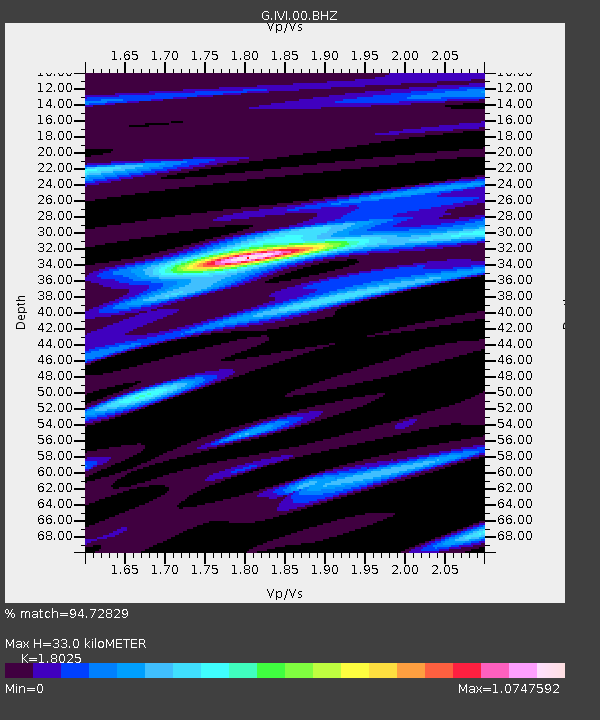
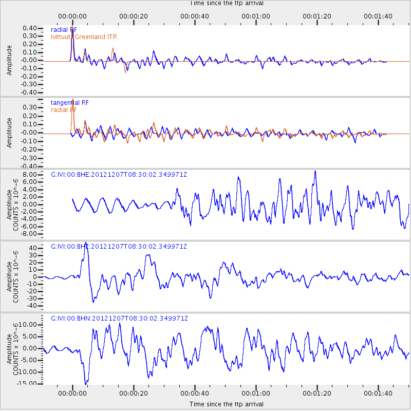
IVI Ivittuut, Greenland - Earthquake Result Viewer

Earthquake location: Off East Coast Of Honshu, Japan
Earthquake latitude/longitude: 37.9/143.9
Earthquake time(UTC): 2012/12/07 (342) 08:18:23 GMT
Earthquake Depth: 31 km
Earthquake Magnitude: 7.2 MB, 7.3 MS, 7.3 MW, 7.3 MW
Earthquake Catalog/Contributor: WHDF/NEIC
Network: G GEOSCOPE
Station: IVI Ivittuut, Greenland
Lat/Lon: 61.21 N/48.17 W
Elevation: 15 m
Distance: 80.8 deg
Az: 5.911 deg
Baz: 350.311 deg
Ray Param: 0.04801972
Estimated Moho Depth: 33.0 km
Estimated Crust Vp/Vs: 1.80
Assumed Crust Vp: 6.472 km/s
Estimated Crust Vs: 3.59 km/s
Estimated Crust Poisson's Ratio: 0.28
Radial Match: 94.72829 %
Radial Bump: 400
Transverse Match: 82.98845 %
Transverse Bump: 400
SOD ConfigId: 488671
Insert Time: 2013-03-29 04:15:45.396 +0000
GWidth: 2.5
Max Bumps: 400
Tol: 0.001

Signal To Noise

ChannelStoNSTALTA
G:IVI:00:BHZ:20121207T08:30:02.349971Z18.9621322.1847081E-51.1521427E-6
G:IVI:00:BHN:20121207T08:30:02.349971Z5.84385736.522209E-61.1160794E-6
G:IVI:00:BHE:20121207T08:30:02.349971Z1.46103681.6631548E-61.1383387E-6
Arrivals
Ps4.2 SECOND
PpPs14 SECOND
PsPs/PpSs18 SECOND