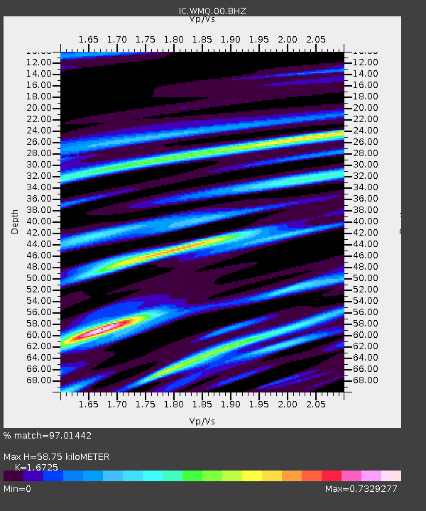
WMQ Urumqi, Xinjiang Province, China - Earthquake Result Viewer

Earthquake location: Off East Coast Of Honshu, Japan
Earthquake latitude/longitude: 37.9/143.9
Earthquake time(UTC): 2012/12/07 (342) 08:18:23 GMT
Earthquake Depth: 31 km
Earthquake Magnitude: 7.2 MB, 7.3 MS, 7.3 MW, 7.3 MW
Earthquake Catalog/Contributor: WHDF/NEIC
Network: IC New China Digital Seismograph Network
Station: WMQ Urumqi, Xinjiang Province, China
Lat/Lon: 43.81 N/87.70 E
Elevation: 850 m
Distance: 42.3 deg
Az: 296.481 deg
Baz: 78.032 deg
Ray Param: 0.07322513
Estimated Moho Depth: 58.75 km
Estimated Crust Vp/Vs: 1.67
Assumed Crust Vp: 6.242 km/s
Estimated Crust Vs: 3.732 km/s
Estimated Crust Poisson's Ratio: 0.22
Radial Match: 97.01442 %
Radial Bump: 400
Transverse Match: 93.49512 %
Transverse Bump: 400
SOD ConfigId: 488671
Insert Time: 2013-03-29 04:16:40.061 +0000
GWidth: 2.5
Max Bumps: 400
Tol: 0.001

Signal To Noise

ChannelStoNSTALTA
IC:WMQ:00:BHZ:20121207T08:25:42.973994Z14.9116111.973147E-61.3232287E-7
IC:WMQ:00:BHN:20121207T08:25:42.973994Z2.94105323.3253124E-71.1306536E-7
IC:WMQ:00:BHE:20121207T08:25:42.973994Z7.217091.0713555E-61.4844703E-7
Arrivals
Ps6.8 SECOND
PpPs24 SECOND
PsPs/PpSs30 SECOND