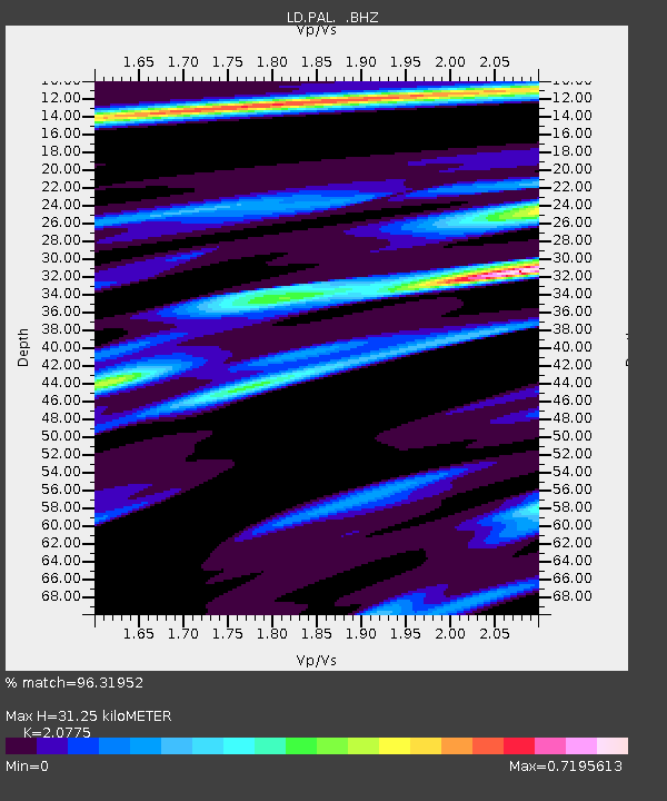
PAL Palisades, New York - Earthquake Result Viewer

Earthquake location: Off East Coast Of Honshu, Japan
Earthquake latitude/longitude: 37.9/143.9
Earthquake time(UTC): 2012/12/07 (342) 08:18:23 GMT
Earthquake Depth: 31 km
Earthquake Magnitude: 7.2 MB, 7.3 MS, 7.3 MW, 7.3 MW
Earthquake Catalog/Contributor: WHDF/NEIC
Network: LD Lamont-Doherty Cooperative Seismographic Network
Station: PAL Palisades, New York
Lat/Lon: 41.01 N/73.91 W
Elevation: 66 m
Distance: 94.2 deg
Az: 27.755 deg
Baz: 330.867 deg
Ray Param: 0.041090354
Estimated Moho Depth: 31.25 km
Estimated Crust Vp/Vs: 2.08
Assumed Crust Vp: 6.472 km/s
Estimated Crust Vs: 3.115 km/s
Estimated Crust Poisson's Ratio: 0.35
Radial Match: 96.31952 %
Radial Bump: 263
Transverse Match: 81.84274 %
Transverse Bump: 400
SOD ConfigId: 488671
Insert Time: 2013-03-29 04:19:07.671 +0000
GWidth: 2.5
Max Bumps: 400
Tol: 0.001

Signal To Noise

ChannelStoNSTALTA
LD:PAL: :BHZ:20121207T08:31:07.49499Z16.648598.708904E-65.231016E-7
LD:PAL: :BHN:20121207T08:31:07.49499Z7.4852452.4745243E-63.3058691E-7
LD:PAL: :BHE:20121207T08:31:07.49499Z5.0011871.139159E-62.2777773E-7
Arrivals
Ps5.3 SECOND
PpPs15 SECOND
PsPs/PpSs20 SECOND