You are here: Home > Network List > NE - New England Seismic Network Stations List
> Station BCX Chestnut Hill, MA, USA > Earthquake Result Viewer
BCX Chestnut Hill, MA, USA - Earthquake Result Viewer
| Earthquake location: |
Off East Coast Of Honshu, Japan |
| Earthquake latitude/longitude: |
37.9/143.9 |
| Earthquake time(UTC): |
2012/12/07 (342) 08:18:23 GMT |
| Earthquake Depth: |
31 km |
| Earthquake Magnitude: |
7.2 MB, 7.3 MS, 7.3 MW, 7.3 MW |
| Earthquake Catalog/Contributor: |
WHDF/NEIC |
|
| Network: |
NE New England Seismic Network |
| Station: |
BCX Chestnut Hill, MA, USA |
| Lat/Lon: |
42.33 N/71.17 W |
| Elevation: |
60 m |
|
| Distance: |
94.0 deg |
| Az: |
25.315 deg |
| Baz: |
332.854 deg |
| Ray Param: |
0.041137658 |
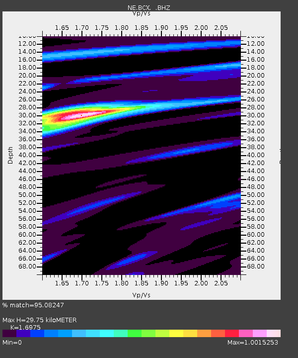
| Estimated Moho Depth: |
29.75 km |
| Estimated Crust Vp/Vs: |
1.70 |
| Assumed Crust Vp: |
6.419 km/s |
| Estimated Crust Vs: |
3.782 km/s |
| Estimated Crust Poisson's Ratio: |
0.23 |
|
| Radial Match: |
95.08247 % |
| Radial Bump: |
364 |
| Transverse Match: |
84.890724 % |
| Transverse Bump: |
400 |
| SOD ConfigId: |
488671 |
| Insert Time: |
2013-03-29 04:21:10.340 +0000 |
| GWidth: |
2.5 |
| Max Bumps: |
400 |
| Tol: |
0.001 |
|

Signal To Noise
| Channel | StoN | STA | LTA |
| NE:BCX: :BHZ:20121207T08:31:06.554988Z | 17.736092 | 6.9769644E-6 | 3.9337664E-7 |
| NE:BCX: :BHN:20121207T08:31:06.554988Z | 5.9286904 | 2.0581713E-6 | 3.4715444E-7 |
| NE:BCX: :BHE:20121207T08:31:06.554988Z | 3.4634876 | 9.77464E-7 | 2.8221956E-7 |
| Arrivals |
| Ps | 3.3 SECOND |
| PpPs | 12 SECOND |
| PsPs/PpSs | 16 SECOND |


