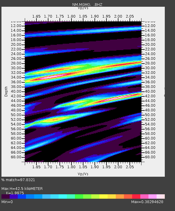
MGMO Mountain Grove, MO - Earthquake Result Viewer

Earthquake location: Off East Coast Of Honshu, Japan
Earthquake latitude/longitude: 37.9/143.9
Earthquake time(UTC): 2012/12/07 (342) 08:18:23 GMT
Earthquake Depth: 31 km
Earthquake Magnitude: 7.2 MB, 7.3 MS, 7.3 MW, 7.3 MW
Earthquake Catalog/Contributor: WHDF/NEIC
Network: NM Cooperative New Madrid Seismic Network
Station: MGMO Mountain Grove, MO
Lat/Lon: 37.15 N/92.27 W
Elevation: 453 m
Distance: 89.1 deg
Az: 41.617 deg
Baz: 318.876 deg
Ray Param: 0.042084176
Estimated Moho Depth: 42.5 km
Estimated Crust Vp/Vs: 2.00
Assumed Crust Vp: 6.53 km/s
Estimated Crust Vs: 3.269 km/s
Estimated Crust Poisson's Ratio: 0.33
Radial Match: 97.8321 %
Radial Bump: 307
Transverse Match: 95.09973 %
Transverse Bump: 400
SOD ConfigId: 488671
Insert Time: 2013-03-29 04:22:45.574 +0000
GWidth: 2.5
Max Bumps: 400
Tol: 0.001

Signal To Noise

ChannelStoNSTALTA
NM:MGMO: :BHZ:20121207T08:30:43.86999Z40.9429131.2227126E-52.9863838E-7
NM:MGMO: :BHN:20121207T08:30:43.86999Z12.5167113.7085917E-62.9629123E-7
NM:MGMO: :BHE:20121207T08:30:43.86999Z13.9802972.6182925E-61.8728447E-7
Arrivals
Ps6.6 SECOND
PpPs19 SECOND
PsPs/PpSs26 SECOND