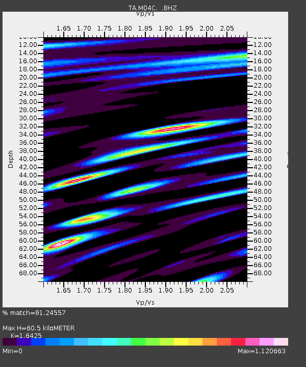
M04C Macdoel, CA, USA - Earthquake Result Viewer
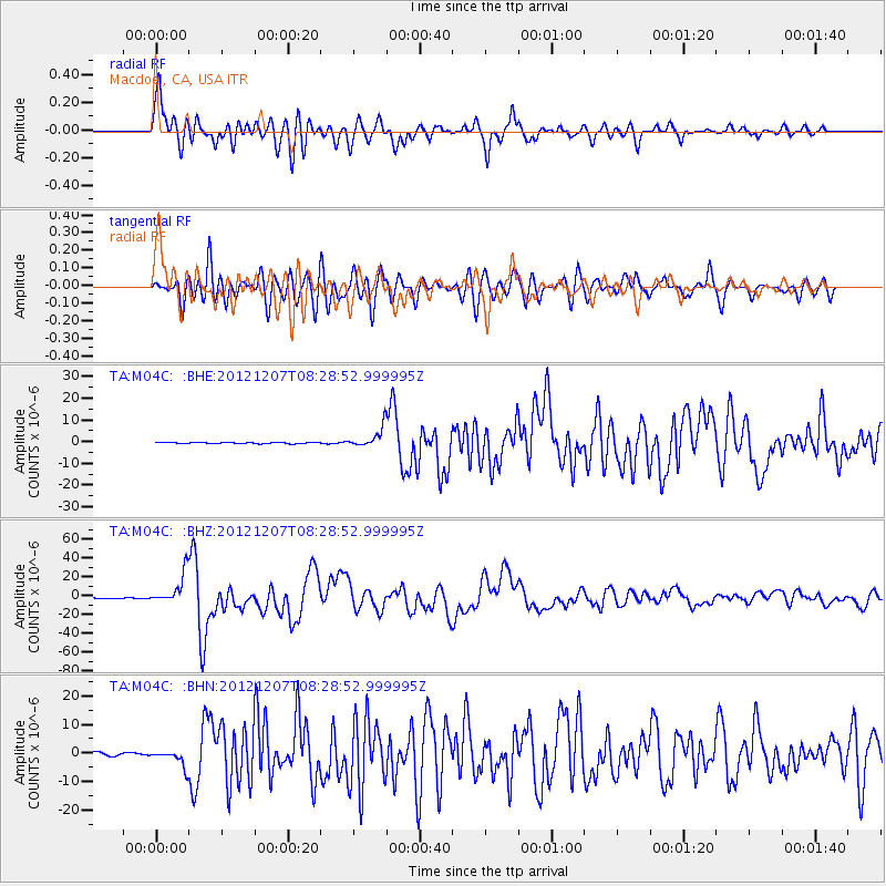
Earthquake location: Off East Coast Of Honshu, Japan
Earthquake latitude/longitude: 37.9/143.9
Earthquake time(UTC): 2012/12/07 (342) 08:18:23 GMT
Earthquake Depth: 31 km
Earthquake Magnitude: 7.2 MB, 7.3 MS, 7.3 MW, 7.3 MW
Earthquake Catalog/Contributor: WHDF/NEIC
Network: TA USArray Transportable Network (new EarthScope stations)
Station: M04C Macdoel, CA, USA
Lat/Lon: 41.78 N/121.84 W
Elevation: 1391 m
Distance: 68.7 deg
Az: 53.16 deg
Baz: 302.152 deg
Ray Param: 0.056056995
Estimated Moho Depth: 60.5 km
Estimated Crust Vp/Vs: 1.64
Assumed Crust Vp: 6.566 km/s
Estimated Crust Vs: 3.998 km/s
Estimated Crust Poisson's Ratio: 0.21
Radial Match: 91.24557 %
Radial Bump: 400
Transverse Match: 87.71928 %
Transverse Bump: 400
SOD ConfigId: 488671
Insert Time: 2013-03-29 04:24:58.352 +0000
GWidth: 2.5
Max Bumps: 400
Tol: 0.001

Signal To Noise

ChannelStoNSTALTA
TA:M04C: :BHZ:20121207T08:28:52.999995Z48.42621.6201713E-53.3456502E-7
TA:M04C: :BHN:20121207T08:28:52.999995Z5.2087162.9694827E-65.700988E-7
TA:M04C: :BHE:20121207T08:28:52.999995Z16.938614.612176E-62.7228774E-7
Arrivals
Ps6.2 SECOND
PpPs23 SECOND
PsPs/PpSs29 SECOND