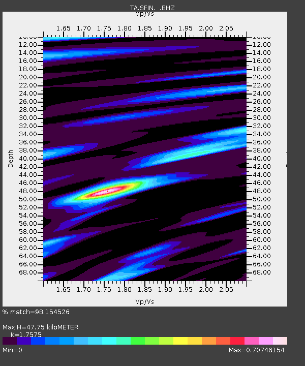
SFIN Lafayette, IN, USA - Earthquake Result Viewer

Earthquake location: Off East Coast Of Honshu, Japan
Earthquake latitude/longitude: 37.9/143.9
Earthquake time(UTC): 2012/12/07 (342) 08:18:23 GMT
Earthquake Depth: 31 km
Earthquake Magnitude: 7.2 MB, 7.3 MS, 7.3 MW, 7.3 MW
Earthquake Catalog/Contributor: WHDF/NEIC
Network: TA USArray Transportable Network (new EarthScope stations)
Station: SFIN Lafayette, IN, USA
Lat/Lon: 40.38 N/87.10 W
Elevation: 165 m
Distance: 89.2 deg
Az: 36.45 deg
Baz: 322.024 deg
Ray Param: 0.04201606
Estimated Moho Depth: 47.75 km
Estimated Crust Vp/Vs: 1.76
Assumed Crust Vp: 6.498 km/s
Estimated Crust Vs: 3.697 km/s
Estimated Crust Poisson's Ratio: 0.26
Radial Match: 98.154526 %
Radial Bump: 356
Transverse Match: 90.57165 %
Transverse Bump: 400
SOD ConfigId: 488671
Insert Time: 2013-03-29 04:26:27.183 +0000
GWidth: 2.5
Max Bumps: 400
Tol: 0.001

Signal To Noise

ChannelStoNSTALTA
TA:SFIN: :BHZ:20121207T08:30:44.325007Z40.8803331.5487813E-53.788573E-7
TA:SFIN: :BHN:20121207T08:30:44.325007Z10.3058913.913388E-63.797234E-7
TA:SFIN: :BHE:20121207T08:30:44.325007Z12.444442.769219E-62.2252661E-7
Arrivals
Ps5.7 SECOND
PpPs20 SECOND
PsPs/PpSs26 SECOND