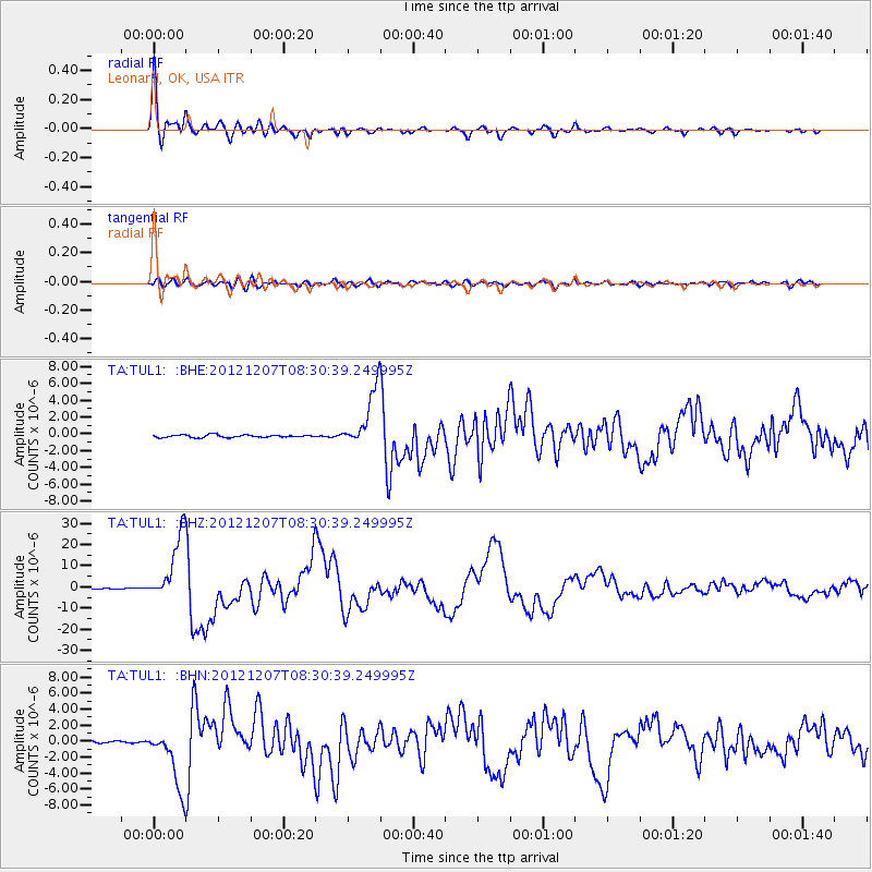
TUL1 Leonard, OK, USA - Earthquake Result Viewer
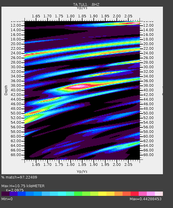
Earthquake location: Off East Coast Of Honshu, Japan
Earthquake latitude/longitude: 37.9/143.9
Earthquake time(UTC): 2012/12/07 (342) 08:18:23 GMT
Earthquake Depth: 31 km
Earthquake Magnitude: 7.2 MB, 7.3 MS, 7.3 MW, 7.3 MW
Earthquake Catalog/Contributor: WHDF/NEIC
Network: TA USArray Transportable Network (new EarthScope stations)
Station: TUL1 Leonard, OK, USA
Lat/Lon: 35.91 N/95.79 W
Elevation: 256 m
Distance: 88.1 deg
Az: 44.555 deg
Baz: 316.861 deg
Ray Param: 0.042812444
Estimated Moho Depth: 10.75 km
Estimated Crust Vp/Vs: 2.10
Assumed Crust Vp: 6.498 km/s
Estimated Crust Vs: 3.098 km/s
Estimated Crust Poisson's Ratio: 0.35
Radial Match: 97.22489 %
Radial Bump: 390
Transverse Match: 82.34203 %
Transverse Bump: 400
SOD ConfigId: 488671
Insert Time: 2013-03-29 04:26:38.792 +0000
GWidth: 2.5
Max Bumps: 400
Tol: 0.001

Signal To Noise

ChannelStoNSTALTA
TA:TUL1: :BHZ:20121207T08:30:39.249995Z80.492481.5828922E-51.9665094E-7
TA:TUL1: :BHN:20121207T08:30:39.249995Z21.5426733.7960608E-61.7621122E-7
TA:TUL1: :BHE:20121207T08:30:39.249995Z23.1100273.473953E-61.5032232E-7
Arrivals
Ps1.9 SECOND
PpPs5.0 SECOND
PsPs/PpSs6.9 SECOND