You are here: Home > Network List > TA - USArray Transportable Network (new EarthScope stations) Stations List
> Station ABTX Abilene, Hawley, TX, USA > Earthquake Result Viewer
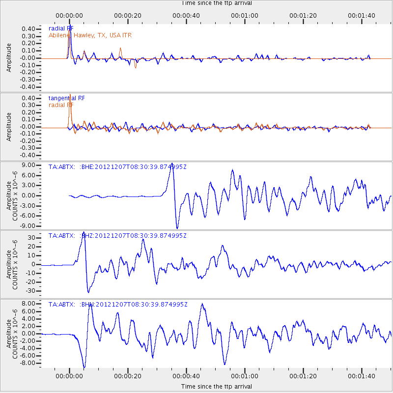
ABTX Abilene, Hawley, TX, USA - Earthquake Result Viewer

| Earthquake location: |
Off East Coast Of Honshu, Japan |
| Earthquake latitude/longitude: |
37.9/143.9 |
| Earthquake time(UTC): |
2012/12/07 (342) 08:18:23 GMT |
| Earthquake Depth: |
31 km |
| Earthquake Magnitude: |
7.2 MB, 7.3 MS, 7.3 MW, 7.3 MW |
| Earthquake Catalog/Contributor: |
WHDF/NEIC |
|
| Network: |
TA USArray Transportable Network (new EarthScope stations) |
| Station: |
ABTX Abilene, Hawley, TX, USA |
| Lat/Lon: |
32.62 N/99.64 W |
| Elevation: |
502 m |
|
| Distance: |
88.2 deg |
| Az: |
49.128 deg |
| Baz: |
314.849 deg |
| Ray Param: |
0.04271587 |
| Estimated Moho Depth: |
31.5 km |
| Estimated Crust Vp/Vs: |
2.03 |
| Assumed Crust Vp: |
6.426 km/s |
| Estimated Crust Vs: |
3.173 km/s |
| Estimated Crust Poisson's Ratio: |
0.34 |
|
| Radial Match: |
97.48775 % |
| Radial Bump: |
291 |
| Transverse Match: |
94.24922 % |
| Transverse Bump: |
400 |
| SOD ConfigId: |
488671 |
| Insert Time: |
2013-03-29 04:27:00.124 +0000 |
| GWidth: |
2.5 |
| Max Bumps: |
400 |
| Tol: |
0.001 |
|
Signal To Noise
| Channel | StoN | STA | LTA |
| TA:ABTX: :BHZ:20121207T08:30:39.874995Z | 99.99743 | 1.46155535E-5 | 1.4615928E-7 |
| TA:ABTX: :BHN:20121207T08:30:39.874995Z | 34.202984 | 3.0235415E-6 | 8.8399936E-8 |
| TA:ABTX: :BHE:20121207T08:30:39.874995Z | 18.458035 | 3.2604125E-6 | 1.766392E-7 |
| Arrivals |
| Ps | 5.1 SECOND |
| PpPs | 15 SECOND |
| PsPs/PpSs | 20 SECOND |


