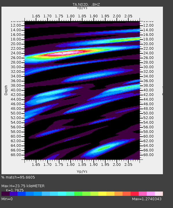
N02D Trinity Center, CA, USA - Earthquake Result Viewer

Earthquake location: Off East Coast Of Honshu, Japan
Earthquake latitude/longitude: 37.9/143.9
Earthquake time(UTC): 2012/12/07 (342) 08:18:23 GMT
Earthquake Depth: 31 km
Earthquake Magnitude: 7.2 MB, 7.3 MS, 7.3 MW, 7.3 MW
Earthquake Catalog/Contributor: WHDF/NEIC
Network: TA USArray Transportable Network (new EarthScope stations)
Station: N02D Trinity Center, CA, USA
Lat/Lon: 40.97 N/122.71 W
Elevation: 937 m
Distance: 68.6 deg
Az: 54.267 deg
Baz: 301.984 deg
Ray Param: 0.056137502
Estimated Moho Depth: 23.75 km
Estimated Crust Vp/Vs: 1.76
Assumed Crust Vp: 6.566 km/s
Estimated Crust Vs: 3.725 km/s
Estimated Crust Poisson's Ratio: 0.26
Radial Match: 95.6605 %
Radial Bump: 400
Transverse Match: 90.55328 %
Transverse Bump: 400
SOD ConfigId: 488671
Insert Time: 2013-03-29 04:27:46.807 +0000
GWidth: 2.5
Max Bumps: 400
Tol: 0.001

Signal To Noise

ChannelStoNSTALTA
TA:N02D: :BHZ:20121207T08:28:52.224971Z61.6712041.0600948E-51.7189463E-7
TA:N02D: :BHN:20121207T08:28:52.224971Z7.46287871.8902899E-62.5329234E-7
TA:N02D: :BHE:20121207T08:28:52.224971Z18.8524323.31454E-61.7581499E-7
Arrivals
Ps2.9 SECOND
PpPs9.6 SECOND
PsPs/PpSs12 SECOND