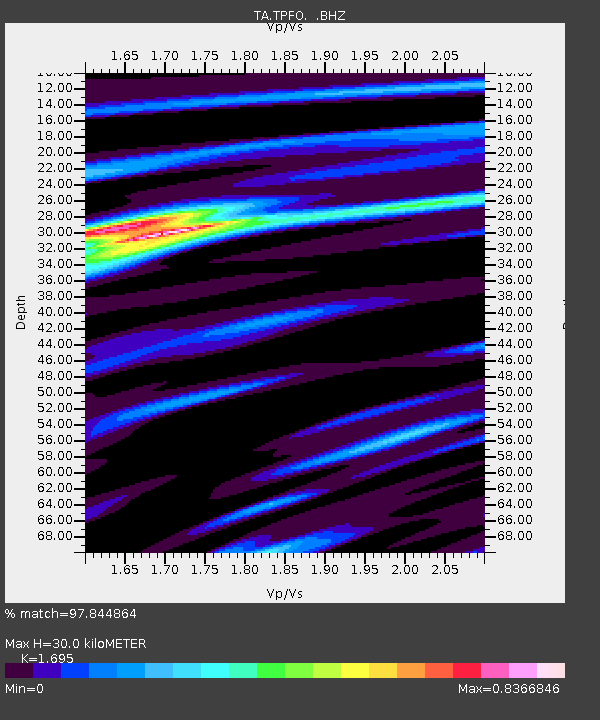
TPFO Pinon Flats, CA, USA - Earthquake Result Viewer
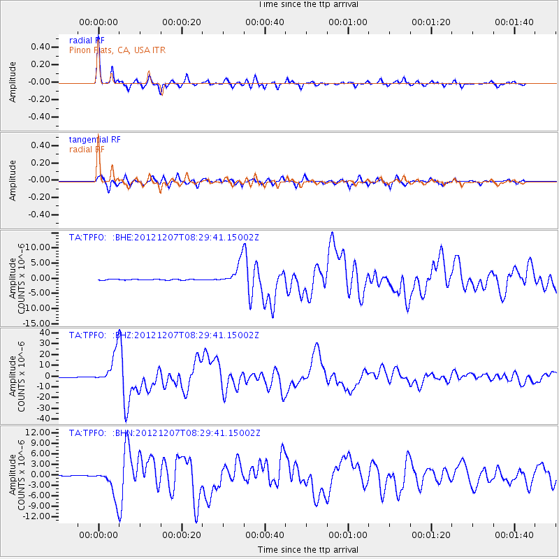
Earthquake location: Off East Coast Of Honshu, Japan
Earthquake latitude/longitude: 37.9/143.9
Earthquake time(UTC): 2012/12/07 (342) 08:18:23 GMT
Earthquake Depth: 31 km
Earthquake Magnitude: 7.2 MB, 7.3 MS, 7.3 MW, 7.3 MW
Earthquake Catalog/Contributor: WHDF/NEIC
Network: TA USArray Transportable Network (new EarthScope stations)
Station: TPFO Pinon Flats, CA, USA
Lat/Lon: 33.61 N/116.45 W
Elevation: 1275 m
Distance: 76.9 deg
Az: 57.663 deg
Baz: 306.775 deg
Ray Param: 0.050649315
Estimated Moho Depth: 30.0 km
Estimated Crust Vp/Vs: 1.70
Assumed Crust Vp: 6.264 km/s
Estimated Crust Vs: 3.695 km/s
Estimated Crust Poisson's Ratio: 0.23
Radial Match: 97.844864 %
Radial Bump: 266
Transverse Match: 89.704834 %
Transverse Bump: 400
SOD ConfigId: 488671
Insert Time: 2013-03-29 04:28:09.704 +0000
GWidth: 2.5
Max Bumps: 400
Tol: 0.001

Signal To Noise

ChannelStoNSTALTA
TA:TPFO: :BHZ:20121207T08:29:41.15002Z73.394691.5961381E-52.1747323E-7
TA:TPFO: :BHN:20121207T08:29:41.15002Z24.5905444.5322176E-61.8430734E-7
TA:TPFO: :BHE:20121207T08:29:41.15002Z32.373194.1822645E-61.2918913E-7
Arrivals
Ps3.4 SECOND
PpPs13 SECOND
PsPs/PpSs16 SECOND