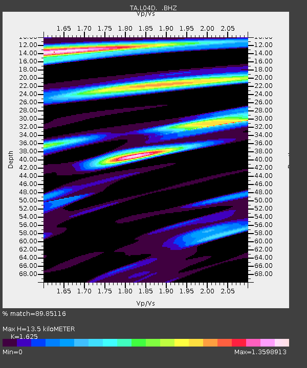
L04D Klamath Falls, OR, USA - Earthquake Result Viewer
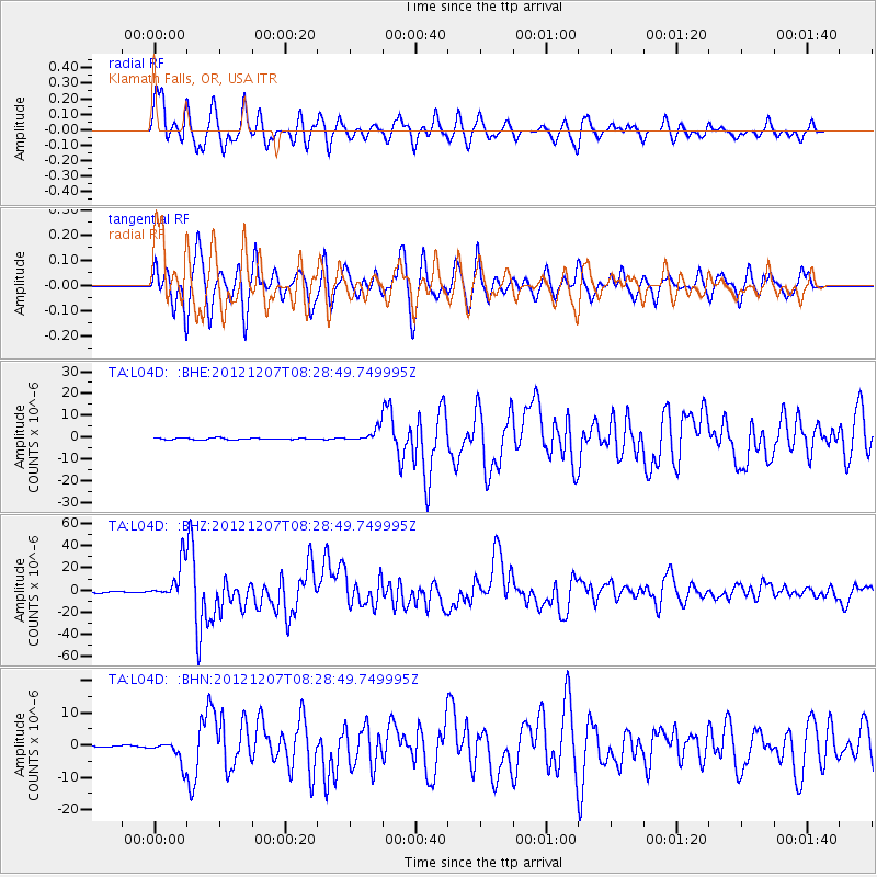
Earthquake location: Off East Coast Of Honshu, Japan
Earthquake latitude/longitude: 37.9/143.9
Earthquake time(UTC): 2012/12/07 (342) 08:18:23 GMT
Earthquake Depth: 31 km
Earthquake Magnitude: 7.2 MB, 7.3 MS, 7.3 MW, 7.3 MW
Earthquake Catalog/Contributor: WHDF/NEIC
Network: TA USArray Transportable Network (new EarthScope stations)
Station: L04D Klamath Falls, OR, USA
Lat/Lon: 42.22 N/122.30 W
Elevation: 1437 m
Distance: 68.2 deg
Az: 52.961 deg
Baz: 301.769 deg
Ray Param: 0.056399863
Estimated Moho Depth: 13.5 km
Estimated Crust Vp/Vs: 1.62
Assumed Crust Vp: 6.522 km/s
Estimated Crust Vs: 4.013 km/s
Estimated Crust Poisson's Ratio: 0.20
Radial Match: 89.85116 %
Radial Bump: 400
Transverse Match: 84.64828 %
Transverse Bump: 400
SOD ConfigId: 488671
Insert Time: 2013-03-29 04:28:17.981 +0000
GWidth: 2.5
Max Bumps: 400
Tol: 0.001

Signal To Noise

ChannelStoNSTALTA
TA:L04D: :BHZ:20121207T08:28:49.749995Z37.0778771.6490645E-54.4475695E-7
TA:L04D: :BHN:20121207T08:28:49.749995Z11.868873.5378675E-62.9807956E-7
TA:L04D: :BHE:20121207T08:28:49.749995Z8.1080983.0026713E-63.7032993E-7
Arrivals
Ps1.4 SECOND
PpPs5.2 SECOND
PsPs/PpSs6.6 SECOND