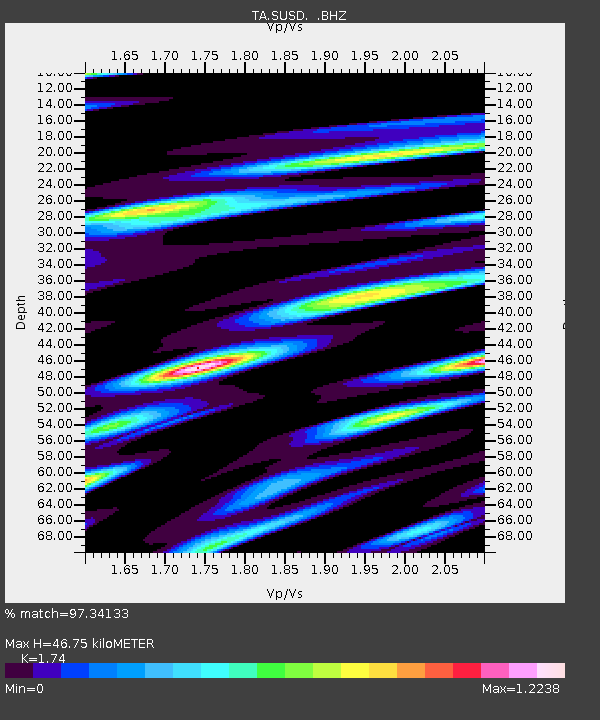
SUSD Miller, SD, USA - Earthquake Result Viewer

Earthquake location: Off East Coast Of Honshu, Japan
Earthquake latitude/longitude: 37.9/143.9
Earthquake time(UTC): 2012/12/07 (342) 08:18:23 GMT
Earthquake Depth: 31 km
Earthquake Magnitude: 7.2 MB, 7.3 MS, 7.3 MW, 7.3 MW
Earthquake Catalog/Contributor: WHDF/NEIC
Network: TA USArray Transportable Network (new EarthScope stations)
Station: SUSD Miller, SD, USA
Lat/Lon: 44.44 N/98.96 W
Elevation: 520 m
Distance: 80.3 deg
Az: 40.312 deg
Baz: 314.391 deg
Ray Param: 0.04833571
Estimated Moho Depth: 46.75 km
Estimated Crust Vp/Vs: 1.74
Assumed Crust Vp: 6.53 km/s
Estimated Crust Vs: 3.753 km/s
Estimated Crust Poisson's Ratio: 0.25
Radial Match: 97.34133 %
Radial Bump: 400
Transverse Match: 95.661 %
Transverse Bump: 400
SOD ConfigId: 488671
Insert Time: 2013-03-29 04:28:46.092 +0000
GWidth: 2.5
Max Bumps: 400
Tol: 0.001

Signal To Noise

ChannelStoNSTALTA
TA:SUSD: :BHZ:20121207T08:29:59.825007Z150.715272.3755154E-51.576161E-7
TA:SUSD: :BHN:20121207T08:29:59.825007Z28.0104148.0315995E-62.867362E-7
TA:SUSD: :BHE:20121207T08:29:59.825007Z27.61467.665332E-62.7758261E-7
Arrivals
Ps5.5 SECOND
PpPs19 SECOND
PsPs/PpSs24 SECOND