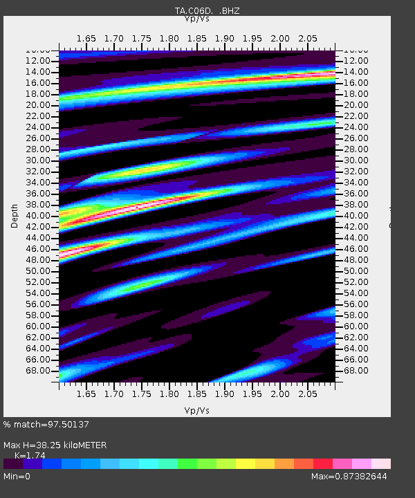
C06D Leavenworth, WQ, USA - Earthquake Result Viewer

Earthquake location: Off East Coast Of Honshu, Japan
Earthquake latitude/longitude: 37.9/143.9
Earthquake time(UTC): 2012/12/07 (342) 08:18:23 GMT
Earthquake Depth: 31 km
Earthquake Magnitude: 7.2 MB, 7.3 MS, 7.3 MW, 7.3 MW
Earthquake Catalog/Contributor: WHDF/NEIC
Network: TA USArray Transportable Network (new EarthScope stations)
Station: C06D Leavenworth, WQ, USA
Lat/Lon: 47.92 N/120.89 W
Elevation: 544 m
Distance: 66.1 deg
Az: 47.102 deg
Baz: 300.49 deg
Ray Param: 0.057773437
Estimated Moho Depth: 38.25 km
Estimated Crust Vp/Vs: 1.74
Assumed Crust Vp: 6.597 km/s
Estimated Crust Vs: 3.792 km/s
Estimated Crust Poisson's Ratio: 0.25
Radial Match: 97.50137 %
Radial Bump: 400
Transverse Match: 92.26249 %
Transverse Bump: 400
SOD ConfigId: 488671
Insert Time: 2013-03-29 04:29:10.532 +0000
GWidth: 2.5
Max Bumps: 400
Tol: 0.001

Signal To Noise

ChannelStoNSTALTA
TA:C06D: :BHZ:20121207T08:28:36.474971Z101.0420151.9147343E-51.8949882E-7
TA:C06D: :BHN:20121207T08:28:36.474971Z25.9379123.9375404E-61.5180638E-7
TA:C06D: :BHE:20121207T08:28:36.474971Z55.2400936.33945E-61.14761754E-7
Arrivals
Ps4.5 SECOND
PpPs15 SECOND
PsPs/PpSs20 SECOND