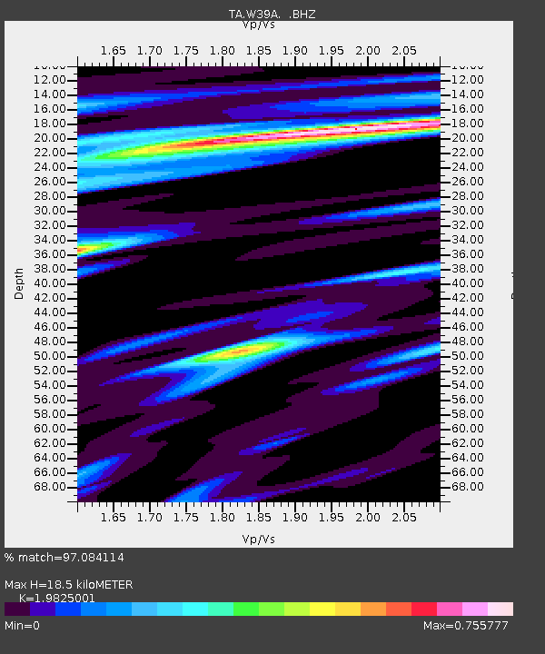
W39A Magazine, AR, USA - Earthquake Result Viewer

Earthquake location: Off East Coast Of Honshu, Japan
Earthquake latitude/longitude: 37.9/143.9
Earthquake time(UTC): 2012/12/07 (342) 08:18:23 GMT
Earthquake Depth: 31 km
Earthquake Magnitude: 7.2 MB, 7.3 MS, 7.3 MW, 7.3 MW
Earthquake Catalog/Contributor: WHDF/NEIC
Network: TA USArray Transportable Network (new EarthScope stations)
Station: W39A Magazine, AR, USA
Lat/Lon: 35.20 N/93.78 W
Elevation: 162 m
Distance: 89.7 deg
Az: 43.831 deg
Baz: 318.009 deg
Ray Param: 0.04172136
Estimated Moho Depth: 18.5 km
Estimated Crust Vp/Vs: 1.98
Assumed Crust Vp: 6.498 km/s
Estimated Crust Vs: 3.277 km/s
Estimated Crust Poisson's Ratio: 0.33
Radial Match: 97.084114 %
Radial Bump: 400
Transverse Match: 85.78075 %
Transverse Bump: 400
SOD ConfigId: 488671
Insert Time: 2013-03-29 04:29:48.170 +0000
GWidth: 2.5
Max Bumps: 400
Tol: 0.001

Signal To Noise

ChannelStoNSTALTA
TA:W39A: :BHZ:20121207T08:30:46.90002Z51.3790471.5224513E-52.9631752E-7
TA:W39A: :BHN:20121207T08:30:46.90002Z14.3517843.4620987E-62.4123125E-7
TA:W39A: :BHE:20121207T08:30:46.90002Z11.9292283.042449E-62.5504156E-7
Arrivals
Ps2.9 SECOND
PpPs8.3 SECOND
PsPs/PpSs11 SECOND