You are here: Home > Network List > TA - USArray Transportable Network (new EarthScope stations) Stations List
> Station Z41A Richland Creek Farm, El Dorado, AR, USA > Earthquake Result Viewer
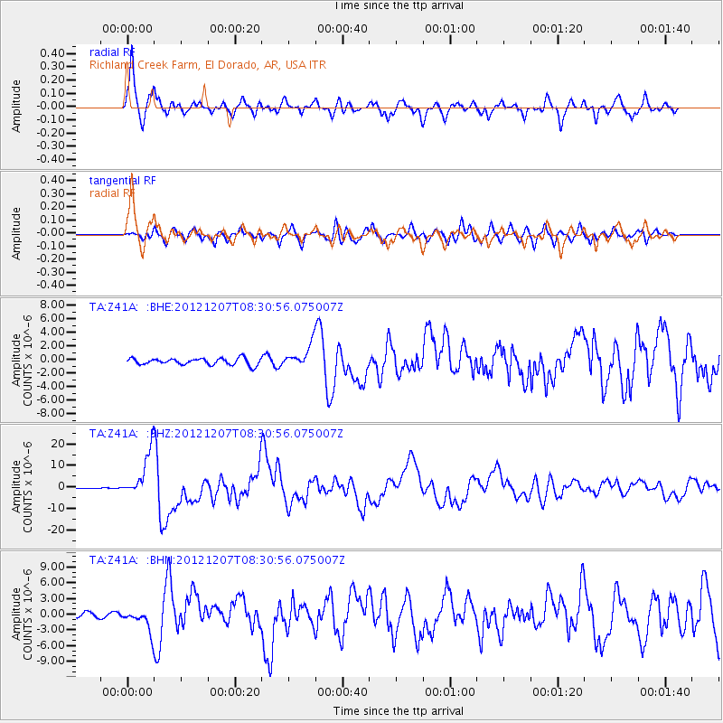
Z41A Richland Creek Farm, El Dorado, AR, USA - Earthquake Result Viewer
| Earthquake location: |
Off East Coast Of Honshu, Japan |
| Earthquake latitude/longitude: |
37.9/143.9 |
| Earthquake time(UTC): |
2012/12/07 (342) 08:18:23 GMT |
| Earthquake Depth: |
31 km |
| Earthquake Magnitude: |
7.2 MB, 7.3 MS, 7.3 MW, 7.3 MW |
| Earthquake Catalog/Contributor: |
WHDF/NEIC |
|
| Network: |
TA USArray Transportable Network (new EarthScope stations) |
| Station: |
Z41A Richland Creek Farm, El Dorado, AR, USA |
| Lat/Lon: |
33.26 N/92.80 W |
| Elevation: |
62 m |
|
| Distance: |
91.7 deg |
| Az: |
44.511 deg |
| Baz: |
318.55 deg |
| Ray Param: |
0.041562594 |
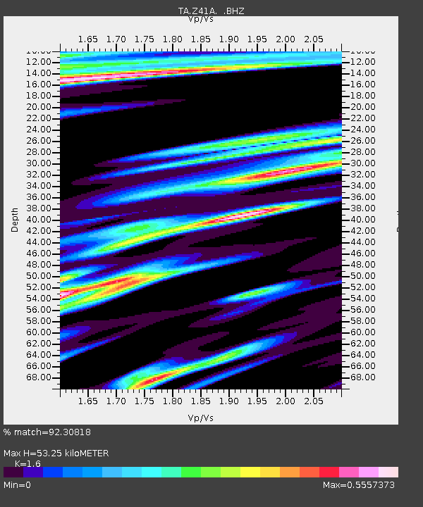
| Estimated Moho Depth: |
53.25 km |
| Estimated Crust Vp/Vs: |
1.60 |
| Assumed Crust Vp: |
6.245 km/s |
| Estimated Crust Vs: |
3.903 km/s |
| Estimated Crust Poisson's Ratio: |
0.18 |
|
| Radial Match: |
92.30818 % |
| Radial Bump: |
400 |
| Transverse Match: |
81.63761 % |
| Transverse Bump: |
400 |
| SOD ConfigId: |
488671 |
| Insert Time: |
2013-03-29 04:30:25.029 +0000 |
| GWidth: |
2.5 |
| Max Bumps: |
400 |
| Tol: |
0.001 |
|
Signal To Noise
| Channel | StoN | STA | LTA |
| TA:Z41A: :BHZ:20121207T08:30:56.075007Z | 49.420082 | 1.0811435E-5 | 2.1876602E-7 |
| TA:Z41A: :BHN:20121207T08:30:56.075007Z | 4.471827 | 2.0982602E-6 | 4.6921764E-7 |
| TA:Z41A: :BHE:20121207T08:30:56.075007Z | 3.593166 | 1.7256186E-6 | 4.802502E-7 |
| Arrivals |
| Ps | 5.2 SECOND |
| PpPs | 22 SECOND |
| PsPs/PpSs | 27 SECOND |


