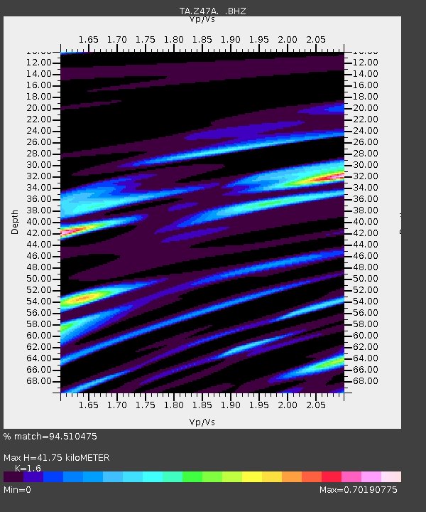
Z47A Carrollton, AL, USA - Earthquake Result Viewer

Earthquake location: Off East Coast Of Honshu, Japan
Earthquake latitude/longitude: 37.9/143.9
Earthquake time(UTC): 2012/12/07 (342) 08:18:23 GMT
Earthquake Depth: 31 km
Earthquake Magnitude: 7.2 MB, 7.3 MS, 7.3 MW, 7.3 MW
Earthquake Catalog/Contributor: WHDF/NEIC
Network: TA USArray Transportable Network (new EarthScope stations)
Station: Z47A Carrollton, AL, USA
Lat/Lon: 33.20 N/88.07 W
Elevation: 65 m
Distance: 94.3 deg
Az: 41.509 deg
Baz: 321.29 deg
Ray Param: 0.041064557
Estimated Moho Depth: 41.75 km
Estimated Crust Vp/Vs: 1.60
Assumed Crust Vp: 6.201 km/s
Estimated Crust Vs: 3.876 km/s
Estimated Crust Poisson's Ratio: 0.18
Radial Match: 94.510475 %
Radial Bump: 400
Transverse Match: 86.62133 %
Transverse Bump: 400
SOD ConfigId: 488671
Insert Time: 2013-03-29 04:32:46.567 +0000
GWidth: 2.5
Max Bumps: 400
Tol: 0.001

Signal To Noise

ChannelStoNSTALTA
TA:Z47A: :BHZ:20121207T08:31:07.999995Z53.1088149.850209E-61.8547219E-7
TA:Z47A: :BHN:20121207T08:31:07.999995Z10.3727042.575697E-62.483149E-7
TA:Z47A: :BHE:20121207T08:31:07.999995Z7.3368621.920432E-62.6175113E-7
Arrivals
Ps4.1 SECOND
PpPs17 SECOND
PsPs/PpSs21 SECOND