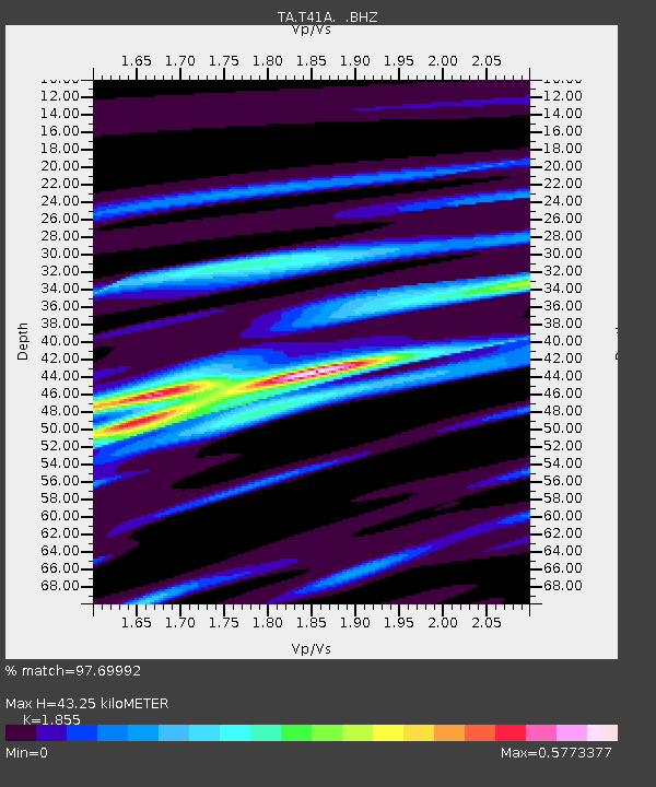
T41A Mountain View, MO, USA - Earthquake Result Viewer
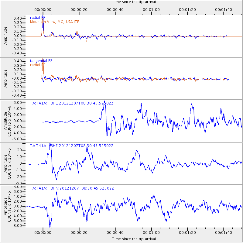
Earthquake location: Off East Coast Of Honshu, Japan
Earthquake latitude/longitude: 37.9/143.9
Earthquake time(UTC): 2012/12/07 (342) 08:18:23 GMT
Earthquake Depth: 31 km
Earthquake Magnitude: 7.2 MB, 7.3 MS, 7.3 MW, 7.3 MW
Earthquake Catalog/Contributor: WHDF/NEIC
Network: TA USArray Transportable Network (new EarthScope stations)
Station: T41A Mountain View, MO, USA
Lat/Lon: 37.04 N/91.76 W
Elevation: 366 m
Distance: 89.4 deg
Az: 41.385 deg
Baz: 319.177 deg
Ray Param: 0.041830704
Estimated Moho Depth: 43.25 km
Estimated Crust Vp/Vs: 1.86
Assumed Crust Vp: 6.53 km/s
Estimated Crust Vs: 3.52 km/s
Estimated Crust Poisson's Ratio: 0.30
Radial Match: 97.69992 %
Radial Bump: 346
Transverse Match: 91.7802 %
Transverse Bump: 400
SOD ConfigId: 488671
Insert Time: 2013-03-29 04:33:29.071 +0000
GWidth: 2.5
Max Bumps: 400
Tol: 0.001

Signal To Noise

ChannelStoNSTALTA
TA:T41A: :BHZ:20121207T08:30:45.52502Z62.9468961.4635309E-52.3250246E-7
TA:T41A: :BHN:20121207T08:30:45.52502Z16.4497623.845023E-62.3374336E-7
TA:T41A: :BHE:20121207T08:30:45.52502Z20.164073.322065E-61.647517E-7
Arrivals
Ps5.8 SECOND
PpPs19 SECOND
PsPs/PpSs24 SECOND