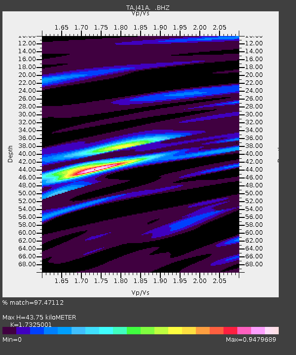
J41A Loganville, WI, USA - Earthquake Result Viewer
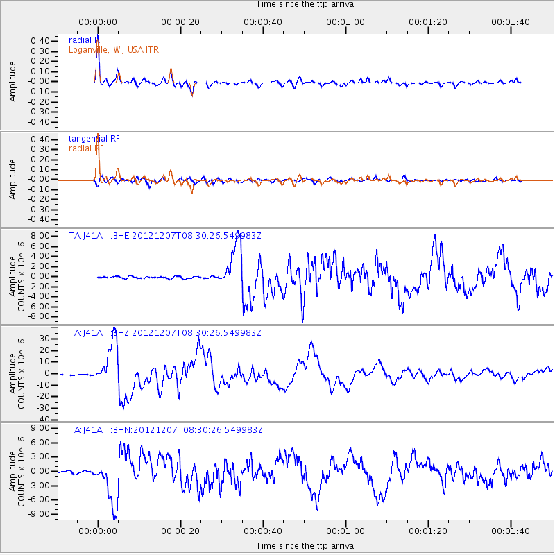
Earthquake location: Off East Coast Of Honshu, Japan
Earthquake latitude/longitude: 37.9/143.9
Earthquake time(UTC): 2012/12/07 (342) 08:18:23 GMT
Earthquake Depth: 31 km
Earthquake Magnitude: 7.2 MB, 7.3 MS, 7.3 MW, 7.3 MW
Earthquake Catalog/Contributor: WHDF/NEIC
Network: TA USArray Transportable Network (new EarthScope stations)
Station: J41A Loganville, WI, USA
Lat/Lon: 43.37 N/90.01 W
Elevation: 360 m
Distance: 85.5 deg
Az: 36.269 deg
Baz: 320.075 deg
Ray Param: 0.04470262
Estimated Moho Depth: 43.75 km
Estimated Crust Vp/Vs: 1.73
Assumed Crust Vp: 6.53 km/s
Estimated Crust Vs: 3.769 km/s
Estimated Crust Poisson's Ratio: 0.25
Radial Match: 97.47112 %
Radial Bump: 333
Transverse Match: 91.33717 %
Transverse Bump: 400
SOD ConfigId: 488671
Insert Time: 2013-03-29 04:35:17.406 +0000
GWidth: 2.5
Max Bumps: 400
Tol: 0.001

Signal To Noise

ChannelStoNSTALTA
TA:J41A: :BHZ:20121207T08:30:26.549983Z98.552732.0001427E-52.0295154E-7
TA:J41A: :BHN:20121207T08:30:26.549983Z18.8398084.9602545E-62.6328584E-7
TA:J41A: :BHE:20121207T08:30:26.549983Z24.5102844.687322E-61.9123898E-7
Arrivals
Ps5.0 SECOND
PpPs18 SECOND
PsPs/PpSs23 SECOND