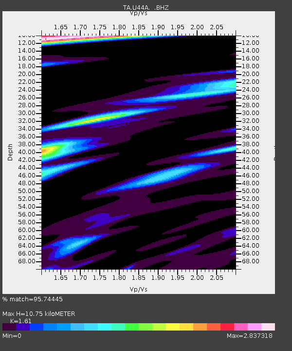
U44A Portageville, MO, USA - Earthquake Result Viewer
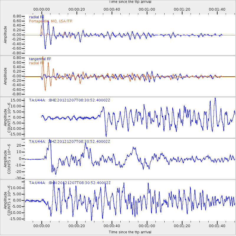
Earthquake location: Off East Coast Of Honshu, Japan
Earthquake latitude/longitude: 37.9/143.9
Earthquake time(UTC): 2012/12/07 (342) 08:18:23 GMT
Earthquake Depth: 31 km
Earthquake Magnitude: 7.2 MB, 7.3 MS, 7.3 MW, 7.3 MW
Earthquake Catalog/Contributor: WHDF/NEIC
Network: TA USArray Transportable Network (new EarthScope stations)
Station: U44A Portageville, MO, USA
Lat/Lon: 36.50 N/89.69 W
Elevation: 89 m
Distance: 90.9 deg
Az: 40.458 deg
Baz: 320.418 deg
Ray Param: 0.041636735
Estimated Moho Depth: 10.75 km
Estimated Crust Vp/Vs: 1.61
Assumed Crust Vp: 6.444 km/s
Estimated Crust Vs: 4.002 km/s
Estimated Crust Poisson's Ratio: 0.19
Radial Match: 95.74445 %
Radial Bump: 400
Transverse Match: 88.22915 %
Transverse Bump: 400
SOD ConfigId: 488671
Insert Time: 2013-03-29 04:36:18.753 +0000
GWidth: 2.5
Max Bumps: 400
Tol: 0.001

Signal To Noise

ChannelStoNSTALTA
TA:U44A: :BHZ:20121207T08:30:52.40002Z53.768941.3122631E-52.4405597E-7
TA:U44A: :BHN:20121207T08:30:52.40002Z4.4372992.827897E-66.3730147E-7
TA:U44A: :BHE:20121207T08:30:52.40002Z3.16392422.9632533E-69.365753E-7
Arrivals
Ps1.0 SECOND
PpPs4.3 SECOND
PsPs/PpSs5.3 SECOND