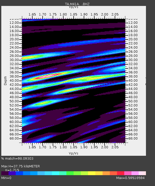
M41A Milan, IL, USA - Earthquake Result Viewer

Earthquake location: Off East Coast Of Honshu, Japan
Earthquake latitude/longitude: 37.9/143.9
Earthquake time(UTC): 2012/12/07 (342) 08:18:23 GMT
Earthquake Depth: 31 km
Earthquake Magnitude: 7.2 MB, 7.3 MS, 7.3 MW, 7.3 MW
Earthquake Catalog/Contributor: WHDF/NEIC
Network: TA USArray Transportable Network (new EarthScope stations)
Station: M41A Milan, IL, USA
Lat/Lon: 41.38 N/90.54 W
Elevation: 226 m
Distance: 86.7 deg
Az: 37.852 deg
Baz: 319.828 deg
Ray Param: 0.043792557
Estimated Moho Depth: 37.75 km
Estimated Crust Vp/Vs: 1.72
Assumed Crust Vp: 6.498 km/s
Estimated Crust Vs: 3.789 km/s
Estimated Crust Poisson's Ratio: 0.24
Radial Match: 98.09303 %
Radial Bump: 400
Transverse Match: 93.60999 %
Transverse Bump: 400
SOD ConfigId: 488671
Insert Time: 2013-03-29 04:36:43.791 +0000
GWidth: 2.5
Max Bumps: 400
Tol: 0.001

Signal To Noise

ChannelStoNSTALTA
TA:M41A: :BHZ:20121207T08:30:32.799983Z86.525172.2410093E-52.5900087E-7
TA:M41A: :BHN:20121207T08:30:32.799983Z28.5739756.515036E-62.2800594E-7
TA:M41A: :BHE:20121207T08:30:32.799983Z20.4383144.6017653E-62.2515387E-7
Arrivals
Ps4.3 SECOND
PpPs15 SECOND
PsPs/PpSs20 SECOND