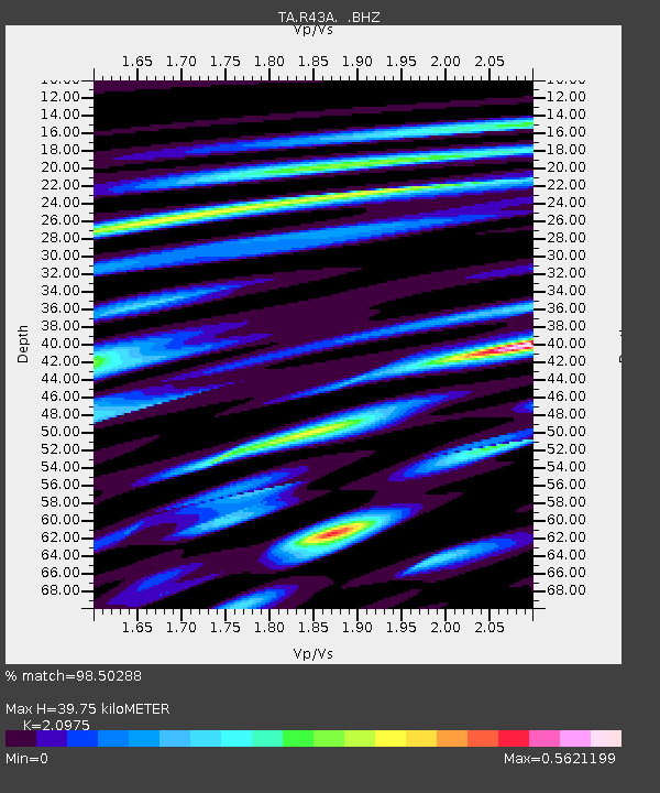
R43A Red Bud, IL, USA - Earthquake Result Viewer

Earthquake location: Off East Coast Of Honshu, Japan
Earthquake latitude/longitude: 37.9/143.9
Earthquake time(UTC): 2012/12/07 (342) 08:18:23 GMT
Earthquake Depth: 31 km
Earthquake Magnitude: 7.2 MB, 7.3 MS, 7.3 MW, 7.3 MW
Earthquake Catalog/Contributor: WHDF/NEIC
Network: TA USArray Transportable Network (new EarthScope stations)
Station: R43A Red Bud, IL, USA
Lat/Lon: 38.28 N/89.93 W
Elevation: 186 m
Distance: 89.4 deg
Az: 39.479 deg
Baz: 320.272 deg
Ray Param: 0.0418294
Estimated Moho Depth: 39.75 km
Estimated Crust Vp/Vs: 2.10
Assumed Crust Vp: 6.444 km/s
Estimated Crust Vs: 3.072 km/s
Estimated Crust Poisson's Ratio: 0.35
Radial Match: 98.50288 %
Radial Bump: 347
Transverse Match: 93.031906 %
Transverse Bump: 400
SOD ConfigId: 488671
Insert Time: 2013-03-29 04:36:54.504 +0000
GWidth: 2.5
Max Bumps: 400
Tol: 0.001

Signal To Noise

ChannelStoNSTALTA
TA:R43A: :BHZ:20121207T08:30:45.52502Z46.624791.5902944E-53.4108345E-7
TA:R43A: :BHN:20121207T08:30:45.52502Z13.5737774.533138E-63.339629E-7
TA:R43A: :BHE:20121207T08:30:45.52502Z18.52653.4787179E-61.8776983E-7
Arrivals
Ps6.9 SECOND
PpPs19 SECOND
PsPs/PpSs26 SECOND