You are here: Home > Network List > TA - USArray Transportable Network (new EarthScope stations) Stations List
> Station U44B Burton Farm, Hornbeak, TN, USA > Earthquake Result Viewer
U44B Burton Farm, Hornbeak, TN, USA - Earthquake Result Viewer
| Earthquake location: |
Off East Coast Of Honshu, Japan |
| Earthquake latitude/longitude: |
37.9/143.9 |
| Earthquake time(UTC): |
2012/12/07 (342) 08:18:23 GMT |
| Earthquake Depth: |
31 km |
| Earthquake Magnitude: |
7.2 MB, 7.3 MS, 7.3 MW, 7.3 MW |
| Earthquake Catalog/Contributor: |
WHDF/NEIC |
|
| Network: |
TA USArray Transportable Network (new EarthScope stations) |
| Station: |
U44B Burton Farm, Hornbeak, TN, USA |
| Lat/Lon: |
36.34 N/89.35 W |
| Elevation: |
136 m |
|
| Distance: |
91.2 deg |
| Az: |
40.354 deg |
| Baz: |
320.618 deg |
| Ray Param: |
0.041615363 |
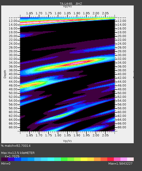
| Estimated Moho Depth: |
12.5 km |
| Estimated Crust Vp/Vs: |
1.70 |
| Assumed Crust Vp: |
6.444 km/s |
| Estimated Crust Vs: |
3.785 km/s |
| Estimated Crust Poisson's Ratio: |
0.24 |
|
| Radial Match: |
92.70014 % |
| Radial Bump: |
400 |
| Transverse Match: |
87.47699 % |
| Transverse Bump: |
400 |
| SOD ConfigId: |
488671 |
| Insert Time: |
2013-03-29 04:37:00.157 +0000 |
| GWidth: |
2.5 |
| Max Bumps: |
400 |
| Tol: |
0.001 |
|
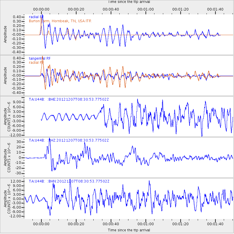
Signal To Noise
| Channel | StoN | STA | LTA |
| TA:U44B: :BHZ:20121207T08:30:53.77502Z | 38.418205 | 1.3420272E-5 | 3.4932066E-7 |
| TA:U44B: :BHN:20121207T08:30:53.77502Z | 3.1650815 | 3.2989412E-6 | 1.0422926E-6 |
| TA:U44B: :BHE:20121207T08:30:53.77502Z | 1.6683937 | 2.3487128E-6 | 1.4077689E-6 |
| Arrivals |
| Ps | 1.4 SECOND |
| PpPs | 5.1 SECOND |
| PsPs/PpSs | 6.5 SECOND |


