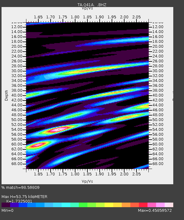
Q41A Truxton, MO, USA - Earthquake Result Viewer
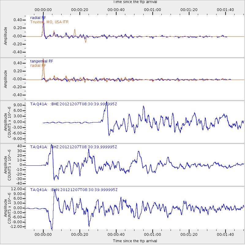
Earthquake location: Off East Coast Of Honshu, Japan
Earthquake latitude/longitude: 37.9/143.9
Earthquake time(UTC): 2012/12/07 (342) 08:18:23 GMT
Earthquake Depth: 31 km
Earthquake Magnitude: 7.2 MB, 7.3 MS, 7.3 MW, 7.3 MW
Earthquake Catalog/Contributor: WHDF/NEIC
Network: TA USArray Transportable Network (new EarthScope stations)
Station: Q41A Truxton, MO, USA
Lat/Lon: 38.95 N/91.23 W
Elevation: 191 m
Distance: 88.2 deg
Az: 39.822 deg
Baz: 319.471 deg
Ray Param: 0.04269428
Estimated Moho Depth: 53.75 km
Estimated Crust Vp/Vs: 1.73
Assumed Crust Vp: 6.498 km/s
Estimated Crust Vs: 3.75 km/s
Estimated Crust Poisson's Ratio: 0.25
Radial Match: 98.59809 %
Radial Bump: 305
Transverse Match: 93.23961 %
Transverse Bump: 400
SOD ConfigId: 488671
Insert Time: 2013-03-29 04:37:10.598 +0000
GWidth: 2.5
Max Bumps: 400
Tol: 0.001

Signal To Noise

ChannelStoNSTALTA
TA:Q41A: :BHZ:20121207T08:30:39.999995Z88.766461.9418872E-52.1876365E-7
TA:Q41A: :BHN:20121207T08:30:39.999995Z33.095525.664764E-61.7116407E-7
TA:Q41A: :BHE:20121207T08:30:39.999995Z26.0748234.4347257E-61.7007693E-7
Arrivals
Ps6.2 SECOND
PpPs22 SECOND
PsPs/PpSs28 SECOND