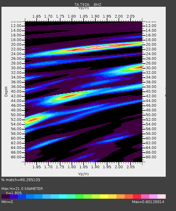
T42A Van Buren, MO, USA - Earthquake Result Viewer

Earthquake location: Off East Coast Of Honshu, Japan
Earthquake latitude/longitude: 37.9/143.9
Earthquake time(UTC): 2012/12/07 (342) 08:18:23 GMT
Earthquake Depth: 31 km
Earthquake Magnitude: 7.2 MB, 7.3 MS, 7.3 MW, 7.3 MW
Earthquake Catalog/Contributor: WHDF/NEIC
Network: TA USArray Transportable Network (new EarthScope stations)
Station: T42A Van Buren, MO, USA
Lat/Lon: 37.03 N/91.09 W
Elevation: 162 m
Distance: 89.8 deg
Az: 40.986 deg
Baz: 319.576 deg
Ray Param: 0.041717153
Estimated Moho Depth: 21.0 km
Estimated Crust Vp/Vs: 1.90
Assumed Crust Vp: 6.53 km/s
Estimated Crust Vs: 3.428 km/s
Estimated Crust Poisson's Ratio: 0.31
Radial Match: 98.295105 %
Radial Bump: 280
Transverse Match: 95.10081 %
Transverse Bump: 400
SOD ConfigId: 488671
Insert Time: 2013-03-29 04:37:45.301 +0000
GWidth: 2.5
Max Bumps: 400
Tol: 0.001

Signal To Noise

ChannelStoNSTALTA
TA:T42A: :BHZ:20121207T08:30:47.174983Z91.351741.6063106E-51.75838E-7
TA:T42A: :BHN:20121207T08:30:47.174983Z20.2381954.277137E-62.1133984E-7
TA:T42A: :BHE:20121207T08:30:47.174983Z19.0951963.6176855E-61.8945528E-7
Arrivals
Ps3.0 SECOND
PpPs9.2 SECOND
PsPs/PpSs12 SECOND