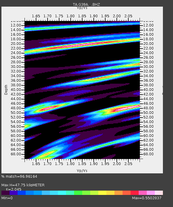
G39A Holcombe, WI, USA - Earthquake Result Viewer

Earthquake location: Off East Coast Of Honshu, Japan
Earthquake latitude/longitude: 37.9/143.9
Earthquake time(UTC): 2012/12/07 (342) 08:18:23 GMT
Earthquake Depth: 31 km
Earthquake Magnitude: 7.2 MB, 7.3 MS, 7.3 MW, 7.3 MW
Earthquake Catalog/Contributor: WHDF/NEIC
Network: TA USArray Transportable Network (new EarthScope stations)
Station: G39A Holcombe, WI, USA
Lat/Lon: 45.29 N/91.17 W
Elevation: 350 m
Distance: 83.5 deg
Az: 35.654 deg
Baz: 319.211 deg
Ray Param: 0.04612646
Estimated Moho Depth: 47.75 km
Estimated Crust Vp/Vs: 2.05
Assumed Crust Vp: 6.571 km/s
Estimated Crust Vs: 3.213 km/s
Estimated Crust Poisson's Ratio: 0.34
Radial Match: 96.96164 %
Radial Bump: 400
Transverse Match: 88.13926 %
Transverse Bump: 400
SOD ConfigId: 488671
Insert Time: 2013-03-29 04:37:56.747 +0000
GWidth: 2.5
Max Bumps: 400
Tol: 0.001

Signal To Noise

ChannelStoNSTALTA
TA:G39A: :BHZ:20121207T08:30:16.474971Z96.522041.8563254E-51.9232141E-7
TA:G39A: :BHN:20121207T08:30:16.474971Z33.63815.3556664E-61.592143E-7
TA:G39A: :BHE:20121207T08:30:16.474971Z30.5281894.8813154E-61.5989535E-7
Arrivals
Ps7.8 SECOND
PpPs22 SECOND
PsPs/PpSs29 SECOND