You are here: Home > Network List > TA - USArray Transportable Network (new EarthScope stations) Stations List
> Station O43A Sugar Creek Farm, Atlanta, IL, USA > Earthquake Result Viewer
O43A Sugar Creek Farm, Atlanta, IL, USA - Earthquake Result Viewer
| Earthquake location: |
Off East Coast Of Honshu, Japan |
| Earthquake latitude/longitude: |
37.9/143.9 |
| Earthquake time(UTC): |
2012/12/07 (342) 08:18:23 GMT |
| Earthquake Depth: |
31 km |
| Earthquake Magnitude: |
7.2 MB, 7.3 MS, 7.3 MW, 7.3 MW |
| Earthquake Catalog/Contributor: |
WHDF/NEIC |
|
| Network: |
TA USArray Transportable Network (new EarthScope stations) |
| Station: |
O43A Sugar Creek Farm, Atlanta, IL, USA |
| Lat/Lon: |
40.29 N/89.31 W |
| Elevation: |
224 m |
|
| Distance: |
88.2 deg |
| Az: |
37.831 deg |
| Baz: |
320.627 deg |
| Ray Param: |
0.04274466 |
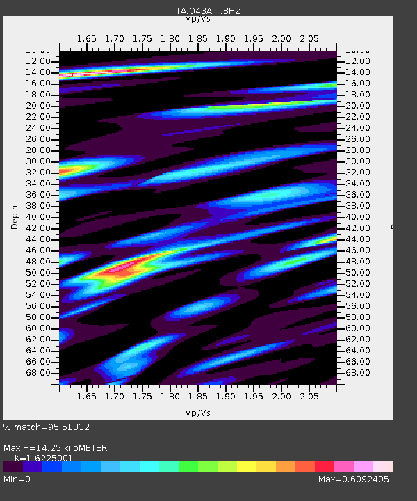
| Estimated Moho Depth: |
14.25 km |
| Estimated Crust Vp/Vs: |
1.62 |
| Assumed Crust Vp: |
6.498 km/s |
| Estimated Crust Vs: |
4.005 km/s |
| Estimated Crust Poisson's Ratio: |
0.19 |
|
| Radial Match: |
95.51832 % |
| Radial Bump: |
400 |
| Transverse Match: |
85.78792 % |
| Transverse Bump: |
400 |
| SOD ConfigId: |
488671 |
| Insert Time: |
2013-03-29 04:38:08.923 +0000 |
| GWidth: |
2.5 |
| Max Bumps: |
400 |
| Tol: |
0.001 |
|
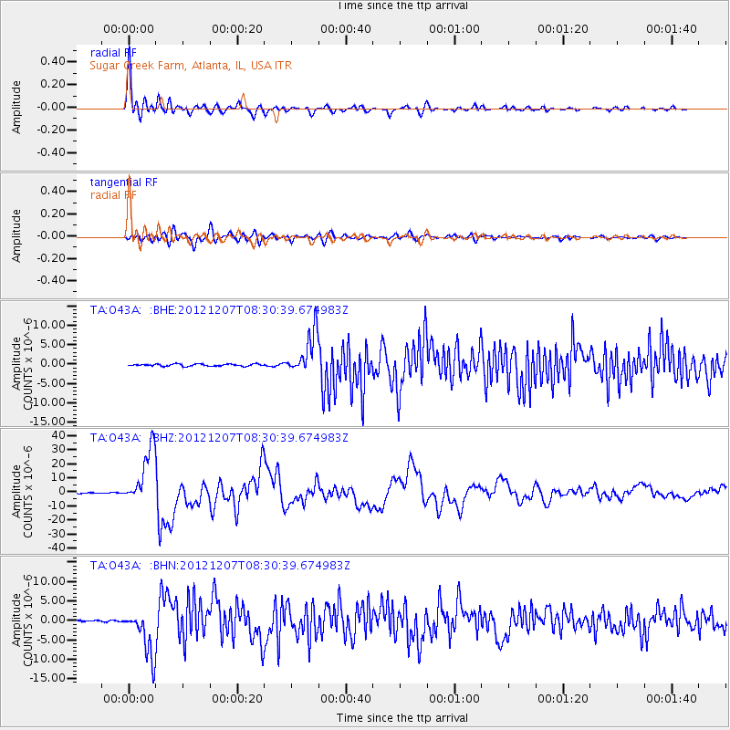
Signal To Noise
| Channel | StoN | STA | LTA |
| TA:O43A: :BHZ:20121207T08:30:39.674983Z | 71.921394 | 2.0122523E-5 | 2.7978493E-7 |
| TA:O43A: :BHN:20121207T08:30:39.674983Z | 20.527056 | 6.0170714E-6 | 2.9312883E-7 |
| TA:O43A: :BHE:20121207T08:30:39.674983Z | 19.785784 | 5.438019E-6 | 2.7484475E-7 |
| Arrivals |
| Ps | 1.4 SECOND |
| PpPs | 5.6 SECOND |
| PsPs/PpSs | 7.0 SECOND |


