You are here: Home > Network List > TA - USArray Transportable Network (new EarthScope stations) Stations List
> Station M40A Post Highland Seismo, Ainsworth, IA, USA > Earthquake Result Viewer
M40A Post Highland Seismo, Ainsworth, IA, USA - Earthquake Result Viewer
| Earthquake location: |
Off East Coast Of Honshu, Japan |
| Earthquake latitude/longitude: |
37.9/143.9 |
| Earthquake time(UTC): |
2012/12/07 (342) 08:18:23 GMT |
| Earthquake Depth: |
31 km |
| Earthquake Magnitude: |
7.2 MB, 7.3 MS, 7.3 MW, 7.3 MW |
| Earthquake Catalog/Contributor: |
WHDF/NEIC |
|
| Network: |
TA USArray Transportable Network (new EarthScope stations) |
| Station: |
M40A Post Highland Seismo, Ainsworth, IA, USA |
| Lat/Lon: |
41.41 N/91.51 W |
| Elevation: |
223 m |
|
| Distance: |
86.2 deg |
| Az: |
38.388 deg |
| Baz: |
319.222 deg |
| Ray Param: |
0.044152196 |
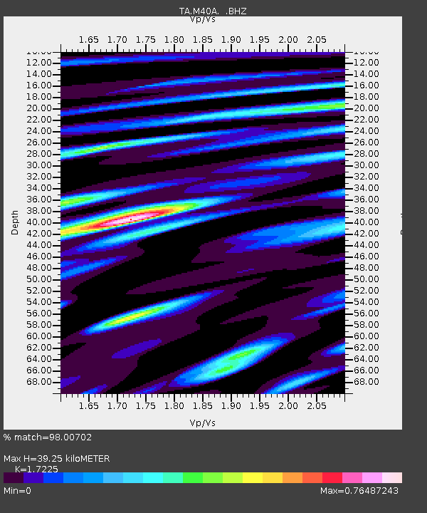
| Estimated Moho Depth: |
39.25 km |
| Estimated Crust Vp/Vs: |
1.72 |
| Assumed Crust Vp: |
6.498 km/s |
| Estimated Crust Vs: |
3.772 km/s |
| Estimated Crust Poisson's Ratio: |
0.25 |
|
| Radial Match: |
98.00702 % |
| Radial Bump: |
400 |
| Transverse Match: |
88.383766 % |
| Transverse Bump: |
400 |
| SOD ConfigId: |
488671 |
| Insert Time: |
2013-03-29 04:38:43.722 +0000 |
| GWidth: |
2.5 |
| Max Bumps: |
400 |
| Tol: |
0.001 |
|

Signal To Noise
| Channel | StoN | STA | LTA |
| TA:M40A: :BHZ:20121207T08:30:30.374995Z | 76.35823 | 2.1855187E-5 | 2.8621915E-7 |
| TA:M40A: :BHN:20121207T08:30:30.374995Z | 29.551825 | 6.5757426E-6 | 2.2251562E-7 |
| TA:M40A: :BHE:20121207T08:30:30.374995Z | 27.6409 | 5.1231177E-6 | 1.8534554E-7 |
| Arrivals |
| Ps | 4.5 SECOND |
| PpPs | 16 SECOND |
| PsPs/PpSs | 21 SECOND |


