F41A Wisconsin Rapids, WI, USA - Earthquake Result Viewer
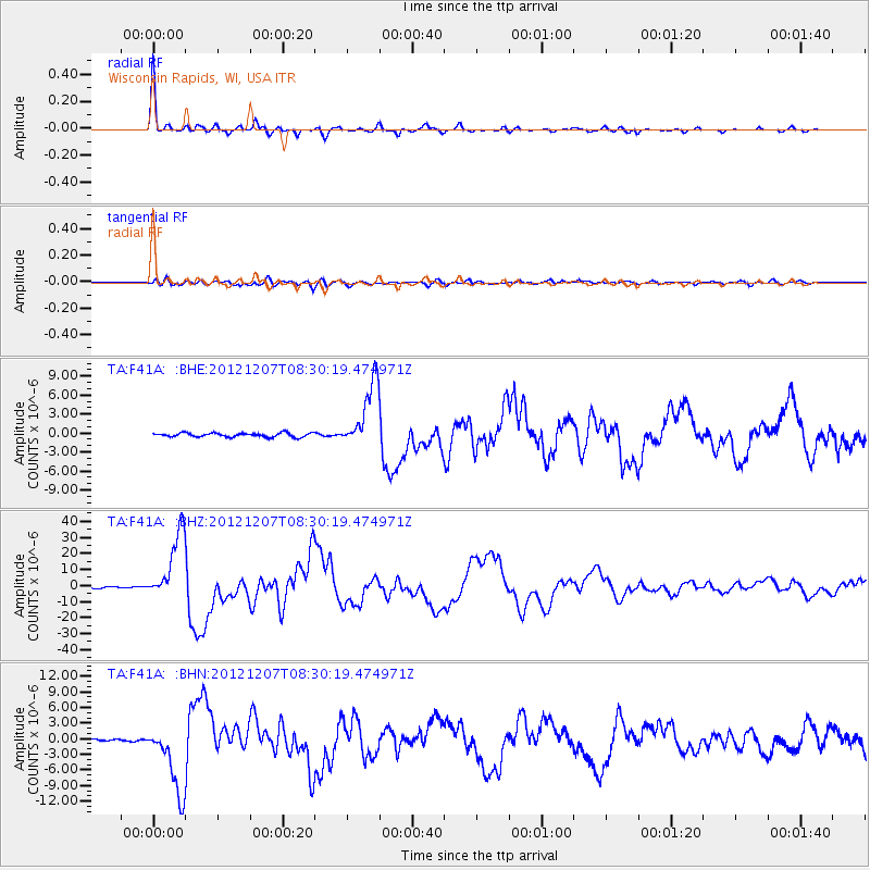
Earthquake location: Off East Coast Of Honshu, Japan
Earthquake latitude/longitude: 37.9/143.9
Earthquake time(UTC): 2012/12/07 (342) 08:18:23 GMT
Earthquake Depth: 31 km
Earthquake Magnitude: 7.2 MB, 7.3 MS, 7.3 MW, 7.3 MW
Earthquake Catalog/Contributor: WHDF/NEIC
Network: TA USArray Transportable Network (new EarthScope stations)
Station: F41A Wisconsin Rapids, WI, USA
Lat/Lon: 45.74 N/89.10 W
Elevation: 509 m
Distance: 84.1 deg
Az: 34.245 deg
Baz: 320.526 deg
Ray Param: 0.045709226
Estimated Moho Depth: 41.5 km
Estimated Crust Vp/Vs: 2.08
Assumed Crust Vp: 6.41 km/s
Estimated Crust Vs: 3.086 km/s
Estimated Crust Poisson's Ratio: 0.35
Radial Match: 98.993706 %
Radial Bump: 272
Transverse Match: 86.423874 %
Transverse Bump: 400
SOD ConfigId: 488671
Insert Time: 2013-03-29 04:38:59.708 +0000
GWidth: 2.5
Max Bumps: 400
Tol: 0.001

Signal To Noise

ChannelStoNSTALTA
TA:F41A: :BHZ:20121207T08:30:19.474971Z51.208482.1467513E-54.192179E-7
TA:F41A: :BHN:20121207T08:30:19.474971Z35.98856.664735E-61.8519069E-7
TA:F41A: :BHE:20121207T08:30:19.474971Z16.5796075.259348E-63.172179E-7
Arrivals
Ps7.1 SECOND
PpPs20 SECOND
PsPs/PpSs27 SECOND