You are here: Home > Network List > TA - USArray Transportable Network (new EarthScope stations) Stations List
> Station F42A Maple Grove Farm, Niagara, WI, USA > Earthquake Result Viewer
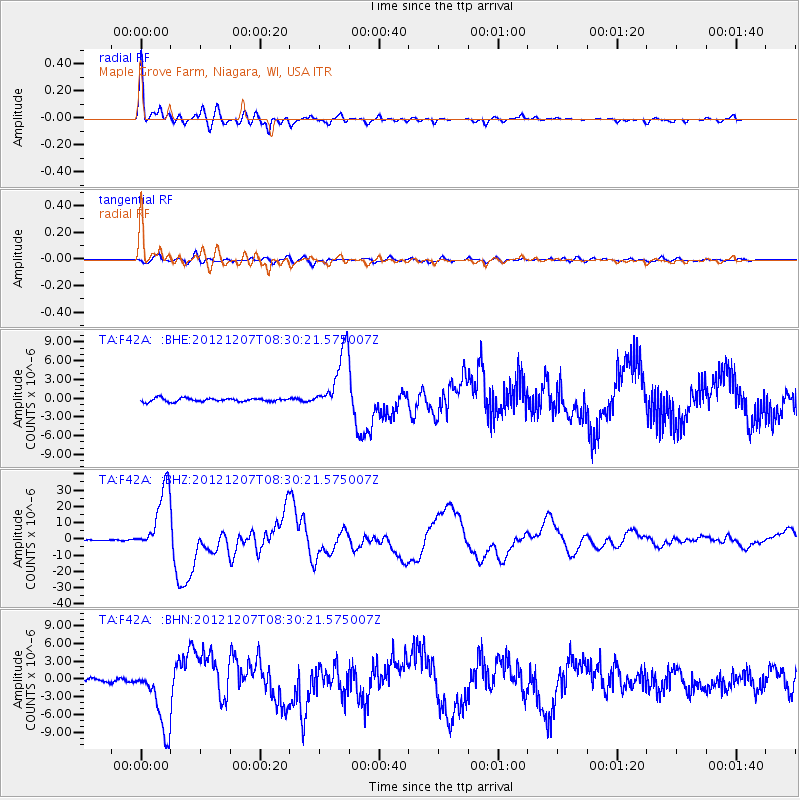
F42A Maple Grove Farm, Niagara, WI, USA - Earthquake Result Viewer

| Earthquake location: |
Off East Coast Of Honshu, Japan |
| Earthquake latitude/longitude: |
37.9/143.9 |
| Earthquake time(UTC): |
2012/12/07 (342) 08:18:23 GMT |
| Earthquake Depth: |
31 km |
| Earthquake Magnitude: |
7.2 MB, 7.3 MS, 7.3 MW, 7.3 MW |
| Earthquake Catalog/Contributor: |
WHDF/NEIC |
|
| Network: |
TA USArray Transportable Network (new EarthScope stations) |
| Station: |
F42A Maple Grove Farm, Niagara, WI, USA |
| Lat/Lon: |
45.76 N/88.13 W |
| Elevation: |
358 m |
|
| Distance: |
84.5 deg |
| Az: |
33.703 deg |
| Baz: |
321.164 deg |
| Ray Param: |
0.04541873 |
| Estimated Moho Depth: |
32.25 km |
| Estimated Crust Vp/Vs: |
1.67 |
| Assumed Crust Vp: |
6.41 km/s |
| Estimated Crust Vs: |
3.844 km/s |
| Estimated Crust Poisson's Ratio: |
0.22 |
|
| Radial Match: |
98.26056 % |
| Radial Bump: |
400 |
| Transverse Match: |
90.07037 % |
| Transverse Bump: |
400 |
| SOD ConfigId: |
488671 |
| Insert Time: |
2013-03-29 04:39:12.322 +0000 |
| GWidth: |
2.5 |
| Max Bumps: |
400 |
| Tol: |
0.001 |
|
Signal To Noise
| Channel | StoN | STA | LTA |
| TA:F42A: :BHZ:20121207T08:30:21.575007Z | 52.45344 | 2.0246078E-5 | 3.8598188E-7 |
| TA:F42A: :BHN:20121207T08:30:21.575007Z | 20.626661 | 5.5082355E-6 | 2.6704447E-7 |
| TA:F42A: :BHE:20121207T08:30:21.575007Z | 17.915907 | 4.9326027E-6 | 2.7531974E-7 |
| Arrivals |
| Ps | 3.4 SECOND |
| PpPs | 13 SECOND |
| PsPs/PpSs | 17 SECOND |


