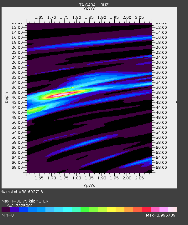
G43A Wallace, MI, USA - Earthquake Result Viewer
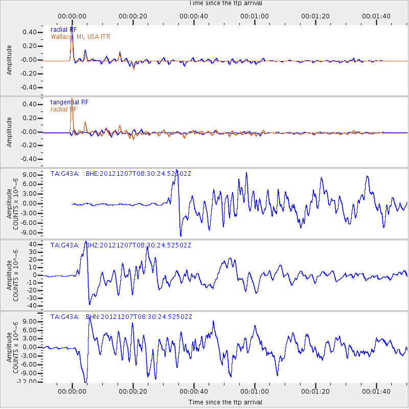
Earthquake location: Off East Coast Of Honshu, Japan
Earthquake latitude/longitude: 37.9/143.9
Earthquake time(UTC): 2012/12/07 (342) 08:18:23 GMT
Earthquake Depth: 31 km
Earthquake Magnitude: 7.2 MB, 7.3 MS, 7.3 MW, 7.3 MW
Earthquake Catalog/Contributor: WHDF/NEIC
Network: TA USArray Transportable Network (new EarthScope stations)
Station: G43A Wallace, MI, USA
Lat/Lon: 45.26 N/87.69 W
Elevation: 213 m
Distance: 85.1 deg
Az: 33.77 deg
Baz: 321.489 deg
Ray Param: 0.044995878
Estimated Moho Depth: 38.75 km
Estimated Crust Vp/Vs: 1.73
Assumed Crust Vp: 6.53 km/s
Estimated Crust Vs: 3.769 km/s
Estimated Crust Poisson's Ratio: 0.25
Radial Match: 98.602715 %
Radial Bump: 247
Transverse Match: 90.192894 %
Transverse Bump: 400
SOD ConfigId: 488671
Insert Time: 2013-03-29 04:39:29.480 +0000
GWidth: 2.5
Max Bumps: 400
Tol: 0.001

Signal To Noise

ChannelStoNSTALTA
TA:G43A: :BHZ:20121207T08:30:24.52502Z71.011842.1480624E-53.0249353E-7
TA:G43A: :BHN:20121207T08:30:24.52502Z30.8109445.945145E-61.9295562E-7
TA:G43A: :BHE:20121207T08:30:24.52502Z27.2445055.0851245E-61.8664771E-7
Arrivals
Ps4.5 SECOND
PpPs16 SECOND
PsPs/PpSs20 SECOND