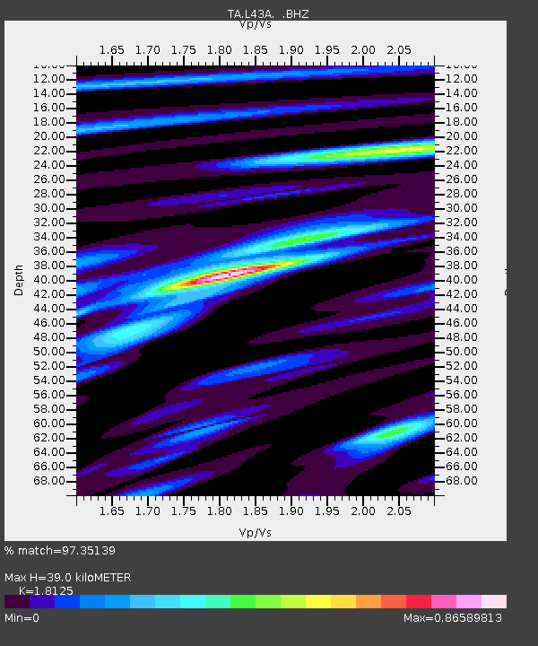
L43A Garden Prairie, IL, USA - Earthquake Result Viewer
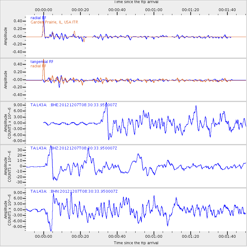
Earthquake location: Off East Coast Of Honshu, Japan
Earthquake latitude/longitude: 37.9/143.9
Earthquake time(UTC): 2012/12/07 (342) 08:18:23 GMT
Earthquake Depth: 31 km
Earthquake Magnitude: 7.2 MB, 7.3 MS, 7.3 MW, 7.3 MW
Earthquake Catalog/Contributor: WHDF/NEIC
Network: TA USArray Transportable Network (new EarthScope stations)
Station: L43A Garden Prairie, IL, USA
Lat/Lon: 42.18 N/88.74 W
Elevation: 266 m
Distance: 87.0 deg
Az: 36.298 deg
Baz: 320.937 deg
Ray Param: 0.043619517
Estimated Moho Depth: 39.0 km
Estimated Crust Vp/Vs: 1.81
Assumed Crust Vp: 6.571 km/s
Estimated Crust Vs: 3.625 km/s
Estimated Crust Poisson's Ratio: 0.28
Radial Match: 97.35139 %
Radial Bump: 400
Transverse Match: 88.864 %
Transverse Bump: 400
SOD ConfigId: 488671
Insert Time: 2013-03-29 04:39:41.289 +0000
GWidth: 2.5
Max Bumps: 400
Tol: 0.001

Signal To Noise

ChannelStoNSTALTA
TA:L43A: :BHZ:20121207T08:30:33.950007Z56.0907361.869756E-53.3334484E-7
TA:L43A: :BHN:20121207T08:30:33.950007Z20.315025.416172E-62.6660925E-7
TA:L43A: :BHE:20121207T08:30:33.950007Z12.3116574.8616284E-63.948801E-7
Arrivals
Ps4.9 SECOND
PpPs16 SECOND
PsPs/PpSs21 SECOND