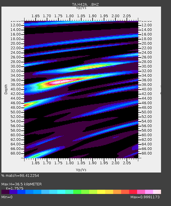
H42A Shiocton, WI, USA - Earthquake Result Viewer
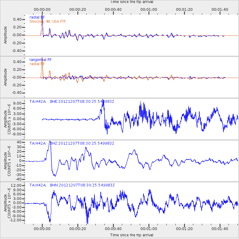
Earthquake location: Off East Coast Of Honshu, Japan
Earthquake latitude/longitude: 37.9/143.9
Earthquake time(UTC): 2012/12/07 (342) 08:18:23 GMT
Earthquake Depth: 31 km
Earthquake Magnitude: 7.2 MB, 7.3 MS, 7.3 MW, 7.3 MW
Earthquake Catalog/Contributor: WHDF/NEIC
Network: TA USArray Transportable Network (new EarthScope stations)
Station: H42A Shiocton, WI, USA
Lat/Lon: 44.51 N/88.53 W
Elevation: 244 m
Distance: 85.3 deg
Az: 34.71 deg
Baz: 320.974 deg
Ray Param: 0.04484713
Estimated Moho Depth: 36.5 km
Estimated Crust Vp/Vs: 1.76
Assumed Crust Vp: 6.41 km/s
Estimated Crust Vs: 3.647 km/s
Estimated Crust Poisson's Ratio: 0.26
Radial Match: 98.412254 %
Radial Bump: 357
Transverse Match: 89.85149 %
Transverse Bump: 400
SOD ConfigId: 488671
Insert Time: 2013-03-29 04:40:16.137 +0000
GWidth: 2.5
Max Bumps: 400
Tol: 0.001

Signal To Noise

ChannelStoNSTALTA
TA:H42A: :BHZ:20121207T08:30:25.549983Z98.988432.0899475E-52.111305E-7
TA:H42A: :BHN:20121207T08:30:25.549983Z30.9162255.7558655E-61.861762E-7
TA:H42A: :BHE:20121207T08:30:25.549983Z26.2162864.7645917E-61.8174167E-7
Arrivals
Ps4.4 SECOND
PpPs15 SECOND
PsPs/PpSs20 SECOND