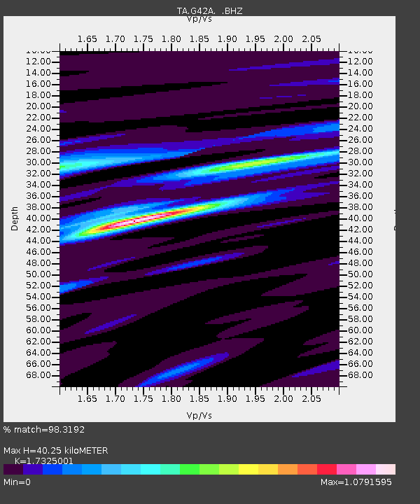
G42A Mountain, WI, USA - Earthquake Result Viewer

Earthquake location: Off East Coast Of Honshu, Japan
Earthquake latitude/longitude: 37.9/143.9
Earthquake time(UTC): 2012/12/07 (342) 08:18:23 GMT
Earthquake Depth: 31 km
Earthquake Magnitude: 7.2 MB, 7.3 MS, 7.3 MW, 7.3 MW
Earthquake Catalog/Contributor: WHDF/NEIC
Network: TA USArray Transportable Network (new EarthScope stations)
Station: G42A Mountain, WI, USA
Lat/Lon: 45.24 N/88.43 W
Elevation: 315 m
Distance: 84.7 deg
Az: 34.19 deg
Baz: 321.002 deg
Ray Param: 0.0452228
Estimated Moho Depth: 40.25 km
Estimated Crust Vp/Vs: 1.73
Assumed Crust Vp: 6.41 km/s
Estimated Crust Vs: 3.7 km/s
Estimated Crust Poisson's Ratio: 0.25
Radial Match: 98.3192 %
Radial Bump: 343
Transverse Match: 92.13954 %
Transverse Bump: 400
SOD ConfigId: 488671
Insert Time: 2013-03-29 04:40:26.585 +0000
GWidth: 2.5
Max Bumps: 400
Tol: 0.001

Signal To Noise

ChannelStoNSTALTA
TA:G42A: :BHZ:20121207T08:30:22.950007Z104.99642.0461443E-51.9487757E-7
TA:G42A: :BHN:20121207T08:30:22.950007Z21.6467065.0649082E-62.3398054E-7
TA:G42A: :BHE:20121207T08:30:22.950007Z29.7662454.645458E-61.5606463E-7
Arrivals
Ps4.7 SECOND
PpPs17 SECOND
PsPs/PpSs21 SECOND