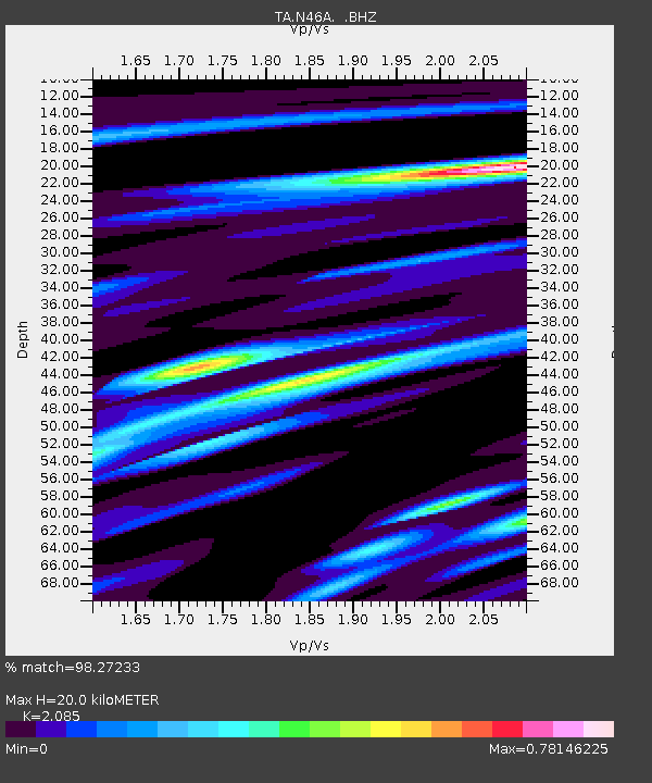
N46A Monticello, IN, USA - Earthquake Result Viewer
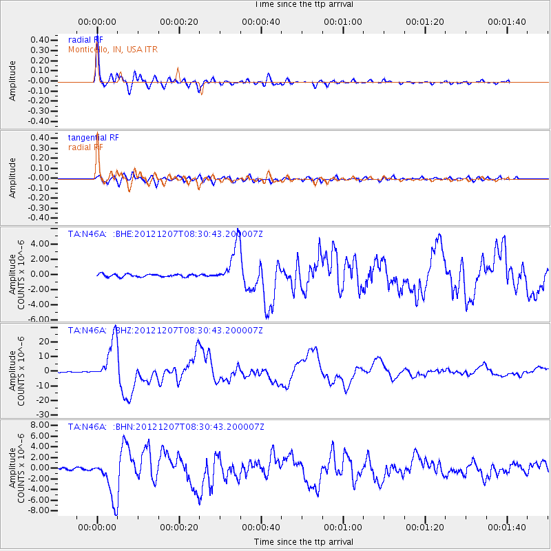
Earthquake location: Off East Coast Of Honshu, Japan
Earthquake latitude/longitude: 37.9/143.9
Earthquake time(UTC): 2012/12/07 (342) 08:18:23 GMT
Earthquake Depth: 31 km
Earthquake Magnitude: 7.2 MB, 7.3 MS, 7.3 MW, 7.3 MW
Earthquake Catalog/Contributor: WHDF/NEIC
Network: TA USArray Transportable Network (new EarthScope stations)
Station: N46A Monticello, IN, USA
Lat/Lon: 40.89 N/86.74 W
Elevation: 209 m
Distance: 88.9 deg
Az: 35.917 deg
Baz: 322.25 deg
Ray Param: 0.04218942
Estimated Moho Depth: 20.0 km
Estimated Crust Vp/Vs: 2.09
Assumed Crust Vp: 6.498 km/s
Estimated Crust Vs: 3.116 km/s
Estimated Crust Poisson's Ratio: 0.35
Radial Match: 98.27233 %
Radial Bump: 369
Transverse Match: 91.21527 %
Transverse Bump: 400
SOD ConfigId: 488671
Insert Time: 2013-03-29 04:41:01.514 +0000
GWidth: 2.5
Max Bumps: 400
Tol: 0.001

Signal To Noise

ChannelStoNSTALTA
TA:N46A: :BHZ:20121207T08:30:43.200007Z63.8669661.4832211E-52.3223603E-7
TA:N46A: :BHN:20121207T08:30:43.200007Z16.7577634.079599E-62.4344533E-7
TA:N46A: :BHE:20121207T08:30:43.200007Z16.2351912.7442254E-61.6902945E-7
Arrivals
Ps3.4 SECOND
PpPs9.3 SECOND
PsPs/PpSs13 SECOND