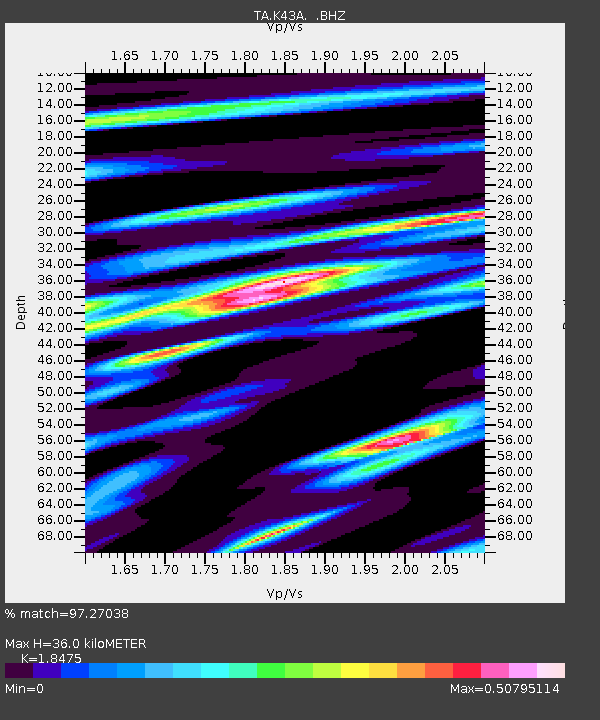
K43A Burlington, WI, USA - Earthquake Result Viewer

Earthquake location: Off East Coast Of Honshu, Japan
Earthquake latitude/longitude: 37.9/143.9
Earthquake time(UTC): 2012/12/07 (342) 08:18:23 GMT
Earthquake Depth: 31 km
Earthquake Magnitude: 7.2 MB, 7.3 MS, 7.3 MW, 7.3 MW
Earthquake Catalog/Contributor: WHDF/NEIC
Network: TA USArray Transportable Network (new EarthScope stations)
Station: K43A Burlington, WI, USA
Lat/Lon: 42.70 N/88.33 W
Elevation: 264 m
Distance: 86.8 deg
Az: 35.733 deg
Baz: 321.182 deg
Ray Param: 0.043776345
Estimated Moho Depth: 36.0 km
Estimated Crust Vp/Vs: 1.85
Assumed Crust Vp: 6.571 km/s
Estimated Crust Vs: 3.557 km/s
Estimated Crust Poisson's Ratio: 0.29
Radial Match: 97.27038 %
Radial Bump: 400
Transverse Match: 89.71431 %
Transverse Bump: 400
SOD ConfigId: 488671
Insert Time: 2013-03-29 04:41:22.739 +0000
GWidth: 2.5
Max Bumps: 400
Tol: 0.001

Signal To Noise

ChannelStoNSTALTA
TA:K43A: :BHZ:20121207T08:30:32.90002Z60.2091751.8118304E-53.0092266E-7
TA:K43A: :BHN:20121207T08:30:32.90002Z17.5759455.353806E-63.0460987E-7
TA:K43A: :BHE:20121207T08:30:32.90002Z19.8776824.7670414E-62.3981877E-7
Arrivals
Ps4.8 SECOND
PpPs15 SECOND
PsPs/PpSs20 SECOND